「サルト県」の版間の差分
m Bot作業依頼: 翻訳用出典テンプレートのsubst展開 (Template:Cite web/French) - log |
|||
| 58行目: | 58行目: | ||
|- |
|- |
||
! colspan="6"| Source : Insee<ref name="Bases"> |
! colspan="6"| Source : Insee<ref name="Bases"> |
||
{{ |
{{cite web2|title=Résultats du recensement de la population - 2012 - Bases de chiffres clés (évolution et structure de la population)|url=http://www.recensement.insee.fr/basesChiffresCles.action|website=INSEE</ref> |
||
| titre = Résultats du recensement de la population - 2012 - Bases de chiffres clés (évolution et structure de la population) |
|||
| site = INSEE |
|||
consulté le= 12 septembre 2010 |
|||
}}</ref> |
|||
|} |
|} |
||
| 69行目: | 65行目: | ||
!コミューン!!人口<br/> 2012!!変遷<br/>2012/1999!!コミューン!!人口<br/> 2012!!変遷<br/>2012/1999 |
!コミューン!!人口<br/> 2012!!変遷<br/>2012/1999!!コミューン!!人口<br/> 2012!!変遷<br/>2012/1999 |
||
|- |
|- |
||
|[[ル・マン]]||{{formatnum:146670}}<ref group="B">{{ |
|[[ル・マン]]||{{formatnum:146670}}<ref group="B">{{cite web2|title=Le Mans|url=http://www.insee.fr/fr/ppp/bases-de-donnees/recensement/populations-legales/commune.asp?depcom=72181&annee=2012|publication-date=}}</ref>||{{increase}} 0,4 %||クラーヌ||{{formatnum:7623}}<ref group="B">{{cite web2|title=Coulaines|url=http://www.insee.fr/fr/ppp/bases-de-donnees/recensement/populations-legales/commune.asp?depcom=72095&annee=2012|publication-date=}}</ref>||{{increase}} 1,0 %|| |
||
|- |
|- |
||
|[[ラ・フレーシュ]]||{{formatnum:16343}}<ref group="B">{{ |
|[[ラ・フレーシュ]]||{{formatnum:16343}}<ref group="B">{{cite web2|title=La Flèche|url=http://www.insee.fr/fr/ppp/bases-de-donnees/recensement/populations-legales/commune.asp?depcom=72154&annee=2012|publication-date=}}</ref>||{{increase}} 7.2 %||シャンジェ||{{formatnum:6268}}<ref group="B">{{cite web2|title=Changé|url=http://www.insee.fr/fr/ppp/bases-de-donnees/recensement/populations-legales/commune.asp?depcom=72058&annee=2012|publication-date=}}</ref>||{{increase}} 20,5 %|| |
||
|- |
|- |
||
|[[サブレ=シュル=サルト]]||{{formatnum:12926}}<ref group="B">{{ |
|[[サブレ=シュル=サルト]]||{{formatnum:12926}}<ref group="B">{{cite web2|title=Sablé-sur-Sarthe|url=http://www.insee.fr/fr/ppp/bases-de-donnees/recensement/populations-legales/commune.asp?depcom=72264&annee=2012|publication-date=}}</ref> ||{{increase}} 1,6 %||[[マメール]]||{{formatnum:5757}}<ref group="B">{{cite web2|title=Mamers|url=http://www.insee.fr/fr/ppp/bases-de-donnees/recensement/populations-legales/commune.asp?depcom=72180&annee=2007|publication-date=}}</ref>||{{decrease}} -5,4 %|| |
||
|- |
|- |
||
|アロンヌ||{{formatnum:11282}}<ref group="B">{{ |
|アロンヌ||{{formatnum:11282}}<ref group="B">{{cite web2|title=Allonnes|url=http://www.insee.fr/fr/ppp/bases-de-donnees/recensement/populations-legales/commune.asp?depcom=72003&annee=2007|publication-date=}}</ref>||{{decrease}} -8,6 %||アルナージュ||{{formatnum:5356}}<ref group="B">{{cite web2|title=Arnage|url=http://www.insee.fr/fr/ppp/bases-de-donnees/recensement/populations-legales/commune.asp?depcom=72008&annee=2007|publication-date=}}</ref>||{{decrease}} -3,8 % |
||
|- |
|- |
||
|ラ・フェルテ=ベルナール||{{formatnum:9622}}<ref group="B">{{ |
|ラ・フェルテ=ベルナール||{{formatnum:9622}}<ref group="B">{{cite web2|title=La Ferté-Bernard|url=http://www.insee.fr/fr/ppp/bases-de-donnees/recensement/populations-legales/commune.asp?depcom=72132&annee=2007|publication-date=}}</ref>||{{increase}} 4,1 %|| |
||
|- |
|- |
||
! colspan="6"| Source : Insee<ref name="Bases"/> |
! colspan="6"| Source : Insee<ref name="Bases"/> |
||
2021年4月15日 (木) 23:13時点における版
| サルト県 Sarthe | |
|---|---|
 サルト県章 | |
| 位置 | |
| 概要 | |
| 県番号 | 72 |
| 地域圏 | ペイ・ド・ラ・ロワール |
| 県庁所在地 | ル・マン |
| 郡庁所在地 |
ラ・フレーシュ マメール |
| 郡 | 3 |
| 小郡 | 40 |
| コミューン | 375 |
| 県議会議長 |
ドミニク・ル・メネール 共和党 (フランス 2015-) |
| 統計 | |
| 人口 国内位 |
(2011年) 565,518人 |
| 人口密度 | 91人/km2 |
| 面積¹ | 6,206 km2 |
| ¹ 「French Land Register data」(1平方キロ以上の湖沼、エスチュアリー、氷河などの水面積除く。 | |
サルト県(サルトけん、仏: Sarthe、フランス語発音: [saʁt])は、フランスのペイ・ド・ラ・ロワール地域圏にある県。県名はサルト川に由来する。
歴史
1789年12月22日の法令によって2つの県に分割された旧メーヌ州の東部をもとにして、フランス革命期の1790年3月4日に設立された。同州の西部はマイエンヌ県となった[1]。
地理

ペイ・ド・ラ・ロワール地域圏の北端に位置し、バス=ノルマンディー地域圏の南、アルモリカ山塊の南縁にあたる。オルヌ県、ウール=エ=ロワール県、ロワール=エ=シェール県、アンドル=エ=ロワール県、メーヌ=エ=ロワール県、マイエンヌ県と隣接する。
県の南部、ロワール川谷沿いはアンジューの一部とみなされており、メーヌ・アンジュヴァン(Maine angevin)とも呼ばれる。県はロワール渓谷の入り口、西のアルモリカ山塊と東のパリ盆地の間の移行地帯に位置する。4箇所ある国有の森とともに、面積の多くが森で覆われており、農村部が主体である。
県西部はアルモリカ山塊の東端にあたり、本質的にカンブリア紀に生じた砂岩である。シレ・ル・ギヨーム周辺ではカンブリア紀以前の片岩である。残りの面積は、パリ盆地に地質的に含まれる広大な堆積岩である。主に泥岩(en)と石灰岩で構成されるジュラ紀の地層は、県北東部で見られる。面積の大部分は白亜紀の初期、セノマニアン(en)にできた。
県の北端にある、ヴィラーヌ・ラ・カレルのベルヴェデール・ド・ペルセーニュは、県の標高最高地点、標高340mである。
ロワール川は県を横断していないが、サルト県はロワールの流域となっている。水路はほぼ4000kmになり、県には3つの主要河川で構成された、非常に密な河川のネットワークがある。県南部を、100km近くにわたって支流のロワール川が横断する。川はポンセ・シュル・ル・ロワールで県に入り、バズージュ・シュル・ル・ロワールで県から出る。県名の由来となっているサルト川は北部を流れる。県都ル・マンではユイヌ川が流れる。
マンシュ海峡と大西洋に近いため、サルトは海洋性気候である。しかし、海の後背地であるため、県はいくらか大陸性気候の影響を受けており、沿岸部より降雨量が少なく、夏は暑い。
経済
経済は1854年の鉄道の開通と1989年のTGVの開業によって、ル・マン地域を中心に発展してきた。道路ではオートルート A11が1978年にパリからル・マンまで開通し、サルト県はフランス西部への玄関口という性格を持つこととなった。
行政
サルト県は375のコミューン、40の小郡、3つの郡で構成される。
| 郡 | 人口 2012 |
人口 1999 |
変遷 2012/1999 |
面積 km2 |
人口密度 hab./km2 |
|---|---|---|---|---|---|
| ル・マン郡 | 267,427 | 255,025 | 837 | 320 | |
| ラ・フレーシュ郡 | 155,495 | 136,953 | 2,521 | 62 | |
| マメール郡 | 153,819 | 137,917 | 2,847 | 54 | |
| Source : Insee[2] | |||||
人口が5000人を超えるコミューンは以下のものである。
| コミューン | 人口 2012 |
変遷 2012/1999 |
コミューン | 人口 2012 |
変遷 2012/1999 | |
|---|---|---|---|---|---|---|
| ル・マン | 146,670[B 1] | クラーヌ | 7,623[B 2] | |||
| ラ・フレーシュ | 16,343[B 3] | シャンジェ | 6,268[B 4] | |||
| サブレ=シュル=サルト | 12,926[B 5] | マメール | 5,757[B 6] | |||
| アロンヌ | 11,282[B 7] | アルナージュ | 5,356[B 8] | |||
| ラ・フェルテ=ベルナール | 9,622[B 9] | |||||
| Source : Insee[2] | ||||||
人口統計
| 1801年 | 1831年 | 1841年 | 1851年 | 1856年 | 1861年 | 1866年 |
|---|---|---|---|---|---|---|
| 388.143 | 457.371 | 470.535 | 473.071 | 467.193 | 466.155 | 463.619 |
| 1872年 | 1876年 | 1881年 | 1886年 | 1891年 | 1896年 | 1901年 |
| 446.603 | 446.239 | 438.917 | 436.111 | 429.737 | 425.077 | 422.699 |
| 1906年 | 1911年 | 1921年 | 1926年 | 1931年 | 1936年 | 1946年 |
| 421.470 | 419.370 | 389.235 | 387.482 | 384.619 | 388.519 | 412.214 |
| 1954年 | 1962年 | 1968年 | 1975年 | 1982年 | 1990年 | 1999年 |
| 420.393 | 443.019 | 461.839 | 490.385 | 504.768 | 513.657 | 529.851 |
ギャラリー
-
ル・マン大聖堂とガロ=ローマ時代の城壁
-
ル・マン大聖堂のステンドグラス
-
現在も続くなかでは世界で最も古い自動車耐久レースであるル・マン24時間レース[3]
-
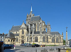
ラ・フェルテ=ベルナールにある教会
-
リュード城
-
クルタンヴォー城
-
ゲルース家の居城だったボワスクレロー城
脚注
- ^ The Sarthe region
- ^ a b {{cite web2|title=Résultats du recensement de la population - 2012 - Bases de chiffres clés (évolution et structure de la population)|url=http://www.recensement.insee.fr/basesChiffresCles.action%7Cwebsite=INSEE
- ^ “Weekly auto agenda: Le Mans”. The Independent. (11 June 2010) 22 April 2011閲覧。
- 2007年1月1日に発表されたINSEEによる各コミューンの人口
- ^ "Le Mans".
{{cite web}}: Cite webテンプレートでは|access-date=引数が必須です。 (説明) - ^ "Coulaines".
{{cite web}}: Cite webテンプレートでは|access-date=引数が必須です。 (説明) - ^ "La Flèche".
{{cite web}}: Cite webテンプレートでは|access-date=引数が必須です。 (説明) - ^ "Changé".
{{cite web}}: Cite webテンプレートでは|access-date=引数が必須です。 (説明) - ^ "Sablé-sur-Sarthe".
{{cite web}}: Cite webテンプレートでは|access-date=引数が必須です。 (説明) - ^ "Mamers".
{{cite web}}: Cite webテンプレートでは|access-date=引数が必須です。 (説明) - ^ "Allonnes".
{{cite web}}: Cite webテンプレートでは|access-date=引数が必須です。 (説明) - ^ "Arnage".
{{cite web}}: Cite webテンプレートでは|access-date=引数が必須です。 (説明) - ^ "La Ferté-Bernard".
{{cite web}}: Cite webテンプレートでは|access-date=引数が必須です。 (説明)
関連項目
- サルト・サーキット - モーターサーキット場
- シルキュイ・ド・ラ・サルト - 毎年開催される自転車レース


![現在も続くなかでは世界で最も古い自動車耐久レースであるル・マン24時間レース[3]](http://upload.wikimedia.org/wikipedia/commons/thumb/5/5e/908_lm2008_montagny.jpg/240px-908_lm2008_montagny.jpg)


