「ウール県」の版間の差分
m Bot作業依頼: 翻訳用出典テンプレートのsubst展開 (Template:Cite web/French) - log |
|||
| 35行目: | 35行目: | ||
4つの代表される景観はウール県で明確に区別されている。セーヌ川谷を意味するヴァレ・ド・ラ・セーヌである。オート=ノルマンディー地域圏の長軸であるセーヌ川谷は、ウール県北東部を横切り、北西においてはセーヌ=マリティーム県との境界となっている。 |
4つの代表される景観はウール県で明確に区別されている。セーヌ川谷を意味するヴァレ・ド・ラ・セーヌである。オート=ノルマンディー地域圏の長軸であるセーヌ川谷は、ウール県北東部を横切り、北西においてはセーヌ=マリティーム県との境界となっている。 |
||
植林の比率は23%あり、旧ノルマンディーの各県で最も森林が多い。森林は主に谷やその周辺に多く、県面積のうち132 775ヘクタールを覆っている。森林の85%が広葉樹で、15%が針葉樹である<ref>{{ |
植林の比率は23%あり、旧ノルマンディーの各県で最も森林が多い。森林は主に谷やその周辺に多く、県面積のうち132 775ヘクタールを覆っている。森林の85%が広葉樹で、15%が針葉樹である<ref>{{cite web2|title=Les forêts dans l'Eure|url=http://www.eure.gouv.fr/Politiques-publiques/Environnement/Nature-Eau/Foret/Les-forets-dans-l-Eure|website=Le site de la préfecture de l'Eure|access-date=16 December 2014|publication-date=}}</ref>。 |
||
==歴史== |
==歴史== |
||
| 73行目: | 73行目: | ||
参照元:SPLAF<ref>http://splaf.free.fr/</ref>、2006年以降[[INSEE]]<ref> |
参照元:SPLAF<ref>http://splaf.free.fr/</ref>、2006年以降[[INSEE]]<ref> |
||
{{cite web2|title=Recensement de la population au 1{{er}} janvier 2006|url=http://www.insee.fr/fr/ppp/bases-de-donnees/recensement/populations-legales/departement.asp?dep=27&annee=2006|website=[[:fr:Institut national de la statistique et des études économiques|Insee]]|publication-date=}}</ref>、2007年<ref name="Struct"> |
|||
{{Lien web |
|||
| ⚫ | {{cite web2|title=Évolution et structure de la population du département (de 1968 à 2007)|url=http://www.recensement.insee.fr/chiffresCles.action?codeMessage=5&zoneSearchField=EURE&codeZone=27-DEP&idTheme=3&rechercher=Rechercher|website=[[:fr:Institut national de la statistique et des études économiques|Insee]]</ref> |
||
|url=http://www.insee.fr/fr/ppp/bases-de-donnees/recensement/populations-legales/departement.asp?dep=27&annee=2006 |
|||
|titre=Recensement de la population au 1{{er}} janvier 2006 |
|||
|site =[[:fr:Institut national de la statistique et des études économiques|Insee]] |
|||
}}</ref>、2007年<ref name="Struct"> |
|||
{{Lien web |
|||
| ⚫ | |||
|titre=Évolution et structure de la population du département (de 1968 à 2007) |
|||
|site =[[:fr:Institut national de la statistique et des études économiques|Insee]] |
|||
consulté le= 8 septembre 2010}}</ref> |
|||
===主要コミューン=== |
===主要コミューン=== |
||
| 90行目: | 82行目: | ||
!コミューン!!人口<br/> 2007!!変遷<br/>2007/1999!!コミューン!!人口<br/> 2007!!変遷<br/>2007/1999 |
!コミューン!!人口<br/> 2007!!変遷<br/>2007/1999!!コミューン!!人口<br/> 2007!!変遷<br/>2007/1999 |
||
|- |
|- |
||
|[[エヴルー]]||{{formatnum:51484}}<ref group="B">{{ |
|[[エヴルー]]||{{formatnum:51484}}<ref group="B">{{cite web2|title=Évreux|url=http://www.insee.fr/fr/ppp/bases-de-donnees/recensement/populations-legales/commune.asp?depcom=27229&annee=2007|publication-date=}}</ref>||== 0,6 %||ポントードメール||{{formatnum:8718}}<ref group="B">{{cite web2|title=Pont-Audemer|url=http://www.insee.fr/fr/ppp/bases-de-donnees/recensement/populations-legales/commune.asp?depcom=27467&annee=2007|publication-date=}}</ref>||{{decrease}} -2,9 % |
||
|- |
|- |
||
|[[ヴェルノン]]||{{formatnum:24598}}<ref group="B">{{ |
|[[ヴェルノン]]||{{formatnum:24598}}<ref group="B">{{cite web2|title=Vernon|url=http://www.insee.fr/fr/ppp/bases-de-donnees/recensement/populations-legales/commune.asp?depcom=27681&annee=2007|publication-date=}}</ref>||{{increase}} 2,2 %||[[レ=ザンドリ]]||{{formatnum:8208}}<ref group="B">{{cite web2|title=Les Andelys|url=http://www.insee.fr/fr/ppp/bases-de-donnees/recensement/populations-legales/commune.asp?depcom=27016&annee=2007|publication-date=}}</ref>||{{decrease}} -9,2 % |
||
|- |
|- |
||
|ルーヴィエ||{{formatnum:18120}}<ref group="B">{{ |
|ルーヴィエ||{{formatnum:18120}}<ref group="B">{{cite web2|title=Louviers|url=http://www.insee.fr/fr/ppp/bases-de-donnees/recensement/populations-legales/commune.asp?depcom=27375&annee=2007|publication-date=}}</ref>||== -1,1 %||ギャヨン||{{formatnum:6879}}<ref group="B">{{cite web2|title=Gaillon|url=http://www.insee.fr/fr/ppp/bases-de-donnees/recensement/populations-legales/commune.asp?depcom=27275&annee=2007|publication-date=}}</ref>||== 0,3 % |
||
|- |
|- |
||
|ヴァル=ド=ルイユ||{{formatnum:13548}}<ref group="B">{{ |
|ヴァル=ド=ルイユ||{{formatnum:13548}}<ref group="B">{{cite web2|title=Val-de-Reuil|url=http://www.insee.fr/fr/ppp/bases-de-donnees/recensement/populations-legales/commune.asp?depcom=27701&annee=2007|publication-date=}}</ref>||{{increase}} 2,3 %||ヴェルヌイユ=シュラーヴル||{{formatnum:6694}}<ref group="B">{{cite web2|title=Verneuil-sur-Avre|url=http://www.insee.fr/fr/ppp/bases-de-donnees/recensement/populations-legales/commune.asp?depcom=27679&annee=2007|publication-date=}}</ref>||== 1,2 % |
||
|- |
|- |
||
|ジゾール||{{formatnum:11677}}<ref group="B">{{ |
|ジゾール||{{formatnum:11677}}<ref group="B">{{cite web2|title=Gisors|url=http://www.insee.fr/fr/ppp/bases-de-donnees/recensement/populations-legales/commune.asp?depcom=27284&annee=2007|publication-date=}}</ref>||{{increase}} 7,3 %||コンシュ=アン=ウシュ||{{formatnum:5046}}<ref group="B">{{cite web2|title=Conches-en-Ouche|url=http://www.insee.fr/fr/ppp/bases-de-donnees/recensement/populations-legales/commune.asp?depcom=27165&annee=2007|publication-date=}}</ref>||{{increase}} 17,8 % |
||
|- |
|- |
||
|[[ベルネー]]||{{formatnum:10434}}<ref group="B">{{ |
|[[ベルネー]]||{{formatnum:10434}}<ref group="B">{{cite web2|title=Bernay|url=http://www.insee.fr/fr/ppp/bases-de-donnees/recensement/populations-legales/commune.asp?depcom=27056&annee=2007|publication-date=}}</ref>||{{decrease}} -5,3 % |
||
|- |
|- |
||
! colspan="6"| 出典 : Insee<ref>http://www.insee.fr/fr/bases-de-donnees/default.asp?page=recensements.htm </ref> |
! colspan="6"| 出典 : Insee<ref>http://www.insee.fr/fr/bases-de-donnees/default.asp?page=recensements.htm </ref> |
||
2021年4月15日 (木) 22:59時点における版
| ウール県 Eure | |
|---|---|
 ウール県章 | |
| 位置 | |
| 概要 | |
| 県番号 | 27 |
| 地域圏 | ノルマンディー |
| 県庁所在地 | エヴルー |
| 郡庁所在地 |
レ=ザンドリ ベルネー |
| 郡 | 3 |
| 小郡 | 43 |
| コミューン | 675 |
| 県議会議長 |
セバスティアン・ルコルニュ |
| 統計 | |
| 人口 国内44位 |
(2011年) 588,111人 |
| 人口密度 | 97人/km2 |
| 面積¹ | 6,040 km2 |
| ¹ 「French Land Register data」(1平方キロ以上の湖沼、エスチュアリー、氷河などの水面積除く。 | |
ウール県(ウールけん、Eure)は、フランスのノルマンディー地域圏の県である。かつてのノルマンディー州廃止後に誕生した5県のうちの1つである。
由来
名称は県内を流れ最後にセーヌ川に合流するウール川に由来する。
地理
ウール県はオート=ノルマンディー地域圏の南部にある。セーヌ=マリティーム県、オワーズ県、ヴァル=ドワーズ県、イヴリーヌ県、ウール=エ=ロワール県、オルヌ県、カルヴァドス県と接している。
県の平均標高は150mである。ウール県は、多かれ少なかれ深い谷で区切られた台地からなる。県には13の自然区分上の地方がある。ペイ・ド・リヨン、ヴェクサン・ノルマン、ヴェクサン・ボシュ、ヴァレ・ド・ラ・セーヌ、プラトー・ド・マドリー、カンパーニュ・ド・サンタンドレ、プラトー・デュ・ヌブール、ペイ・ドゥシュ、ルモワ、リューヴァン、マレ・ヴェルニエ、ペイ・ドージュ、そしてわずかにペルシュである。
4つの代表される景観はウール県で明確に区別されている。セーヌ川谷を意味するヴァレ・ド・ラ・セーヌである。オート=ノルマンディー地域圏の長軸であるセーヌ川谷は、ウール県北東部を横切り、北西においてはセーヌ=マリティーム県との境界となっている。
植林の比率は23%あり、旧ノルマンディーの各県で最も森林が多い。森林は主に谷やその周辺に多く、県面積のうち132 775ヘクタールを覆っている。森林の85%が広葉樹で、15%が針葉樹である[1]。
歴史
1790年3月4日、エヴルー県(Département d'Évreux)の名で新設された[2]。最初県庁が置かれたエヴルーは1793年にその座をベルネーに譲ったが、のちにエヴルーに県庁が復活した[3]。
1790年、エヴルー、レ=ザンドリ、ベルネー、ルーヴィエ、ポントードメール、ヴェルメイユの6郡が置かれた。1800年にはヴェルメイユ郡が廃され、1926年にはポントードメール郡とルーヴィエ郡が廃された。
1815年6月、ワーテルローの戦いで第七次対仏大同盟軍が勝利すると、県はプロイセン軍に1818年11月まで占領されていた。ナポレオン3世による1851年12月2日クーデターの後、ウール県は大規模暴動に対処するため包囲下に置かれた県の1つであった。100人弱が逮捕された[4]。
経済
農業は県面積の3 850 km2を占める重要な産業である。そのうち3 080 km2が穀物、油糧種子、およびたんぱく質作物の生産である。742 km2は恒久的に草原となっている。残りは果樹園や植物種苗場である。
人口統計
| 1801年 | 1831年 | 1841年 | 1851年 | 1856年 | 1861年 | 1866年 |
|---|---|---|---|---|---|---|
| 402.796 | 424.248 | 425.780 | 415.777 | 404.665 | 398.661 | 394.467 |
| 1872年 | 1876年 | 1881年 | 1886年 | 1891年 | 1896年 | 1901年 |
| 377.874 | 373.629 | 364.291 | 358.829 | 349.471 | 340.652 | 334.781 |
| 1906年 | 1911年 | 1921年 | 1926年 | 1931年 | 1936年 | 1946年 |
| 330.140 | 323.651 | 303.159 | 308.445 | 305.788 | 303.829 | 315.902 |
| 1954年 | 1962年 | 1968年 | 1975年 | 1982年 | 1990年 | 1999年 |
| 332.514 | 361.943 | 383.385 | 422.952 | 462.323 | 513.818 | 541.054 |
| 2006年 | 2007年 | |||||
| 554,038 | 572,107 |
参照元:SPLAF[5]、2006年以降INSEE[6]、2007年[7]
主要コミューン
県には675のコミューンがあり、人口が5000人を越えるのは2007年時点で11である。また、103のコミューンは、名称にキリスト教の聖人にちなんだSaintまたはSainteが付いている。
| コミューン | 人口 2007 |
変遷 2007/1999 |
コミューン | 人口 2007 |
変遷 2007/1999 |
|---|---|---|---|---|---|
| エヴルー | 51,484[B 1] | == 0,6 % | ポントードメール | 8,718[B 2] | |
| ヴェルノン | 24,598[B 3] | レ=ザンドリ | 8,208[B 4] | ||
| ルーヴィエ | 18,120[B 5] | == -1,1 % | ギャヨン | 6,879[B 6] | == 0,3 % |
| ヴァル=ド=ルイユ | 13,548[B 7] | ヴェルヌイユ=シュラーヴル | 6,694[B 8] | == 1,2 % | |
| ジゾール | 11,677[B 9] | コンシュ=アン=ウシュ | 5,046[B 10] | ||
| ベルネー | 10,434[B 11] | ||||
| 出典 : Insee[8] | |||||
観光
-
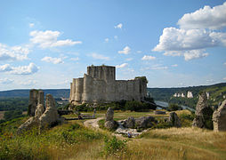
ガイヤール城
-
フランスの最も美しい村に登録されているリヨン=ラ=フォレ
-
レ=ザンドリのセーヌ川谷
-
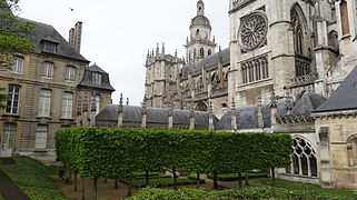
エヴルーのノートルダム大聖堂
脚注
- ^ "Les forêts dans l'Eure". Le site de la préfecture de l'Eure. 2014年12月16日閲覧。
- ^ Marquis de Blosseville, Dictionnaire topographique de la France - Département de l'Eure, 1877, p.80
- ^ Milou (Émile) RIKIR, Les départements et subdivisions de même ordre créés à travers l'Europe et ses colonies entre 1789 et 1815
- ^ Jacques Olivier Boudon, Les Bonaparte : regards sur la France impériale. La Documentation photographique, dossier 8073, janvier-février 2010, p. 11 (carte de fr:Gilles Pécout)
- ^ http://splaf.free.fr/
- ^
"Recensement de la population au 1er janvier 2006". Insee.
{{cite web}}: Cite webテンプレートでは|access-date=引数が必須です。 (説明) - ^ {{cite web2|title=Évolution et structure de la population du département (de 1968 à 2007)|url=http://www.recensement.insee.fr/chiffresCles.action?codeMessage=5&zoneSearchField=EURE&codeZone=27-DEP&idTheme=3&rechercher=Rechercher%7Cwebsite=Insee
- ^ http://www.insee.fr/fr/bases-de-donnees/default.asp?page=recensements.htm
- INSEEサイト上での2007年1月1日のコミューン人口
- ^ "Évreux".
{{cite web}}: Cite webテンプレートでは|access-date=引数が必須です。 (説明) - ^ "Pont-Audemer".
{{cite web}}: Cite webテンプレートでは|access-date=引数が必須です。 (説明) - ^ "Vernon".
{{cite web}}: Cite webテンプレートでは|access-date=引数が必須です。 (説明) - ^ "Les Andelys".
{{cite web}}: Cite webテンプレートでは|access-date=引数が必須です。 (説明) - ^ "Louviers".
{{cite web}}: Cite webテンプレートでは|access-date=引数が必須です。 (説明) - ^ "Gaillon".
{{cite web}}: Cite webテンプレートでは|access-date=引数が必須です。 (説明) - ^ "Val-de-Reuil".
{{cite web}}: Cite webテンプレートでは|access-date=引数が必須です。 (説明) - ^ "Verneuil-sur-Avre".
{{cite web}}: Cite webテンプレートでは|access-date=引数が必須です。 (説明) - ^ "Gisors".
{{cite web}}: Cite webテンプレートでは|access-date=引数が必須です。 (説明) - ^ "Conches-en-Ouche".
{{cite web}}: Cite webテンプレートでは|access-date=引数が必須です。 (説明) - ^ "Bernay".
{{cite web}}: Cite webテンプレートでは|access-date=引数が必須です。 (説明)


