利用者:Yasuko K/sandbox
20:32, 29 August 2018 UTC から翻訳準備のためコピー
 |
ここはYasuko Kさんの利用者サンドボックスです。編集を試したり下書きを置いておいたりするための場所であり、百科事典の記事ではありません。ただし、公開の場ですので、許諾されていない文章の転載はご遠慮ください。
登録利用者は自分用の利用者サンドボックスを作成できます(サンドボックスを作成する、解説)。 その他のサンドボックス: 共用サンドボックス | モジュールサンドボックス 記事がある程度できあがったら、編集方針を確認して、新規ページを作成しましょう。 |
| Emerald Necklace | |
|---|---|
 Boston Public Garden, the second "jewel" of the Emerald Necklace | |
| 分類 | Park system |
| 所在地 | |
| 造成 | 1860s |
| 運営者 | Emerald Necklace Conservancy |
| 開園時間 |
All year |
Olmsted Park System | |
 | |
| 所在地 | Boston and Brookline, Massachusetts |
| 座標 | 北緯42度19分34秒 西経71度06分52秒 / 北緯42.32611度 西経71.11444度座標: 北緯42度19分34秒 西経71度06分52秒 / 北緯42.32611度 西経71.11444度 |
| 建設 | 1870 |
| 建築家 | Olmsted, Frederick Law, Sr. |
| NRHP登録番号 | 71000086 [1] |
| NRHP指定日 | December 8, 1971 |

The Emerald Necklace consists of a 1,100-エーカー (4.5 km2; 450 ha) chain of parks linked by parkways and waterways in Boston and Brookline, Massachusetts. It gets its name from the way the planned chain appears to hang from the "neck" of the Boston peninsula; to this day[要説明] it is not fully constructed. In 1989 the Emerald Necklace Parks was designated as Boston Landmark by the Boston Landmarks Commission.
Overview
[編集]The Necklace comprises half of the City of Boston's park acreage, parkland in the Town of Brookline, and parkways and park edges under the jurisdiction of the Commonwealth of Massachusetts. More than 300,000 people live within its watershed area. From Boston Common to Franklin Park it is approximately seven miles by foot or bicycle through the parks.[2]
The Emerald Necklace includes:
Several components of the Emerald Necklace pre-date the plan to unite them. Some links of the Emerald Necklace not only offer an opportunity for recreation in a wooded environment, but are also ecologically important urban wilds that provide nesting places for migratory birds and improve the air quality of the city.
History
[編集]
This linear system of parks was designed by Frederick Law Olmsted to connect Boston Common, dating from the colonial period, and Public Garden (1837) to Franklin Park, known as the "great country park."
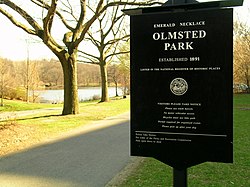
The project began around 1878 with the effort to clean up and control the marshy area which became the Back Bay and The Fens. In 1880, Olmsted proposed that the Muddy River, which flowed from Jamaica Pond through the Fens, be included in the park plan. The current was dredged into a winding stream and directed into the Charles River. The corridor encompassing the river became the linear park still in existence today. Olmsted's vision of a linear park of walking paths along a gentle stream connecting numerous small ponds was complete by the turn of the century. The parks conceived by Olmsted, from Storrow Drive south to Franklin Park, were collectively listed on the National Register of Historic Places as the Olmsted Park System.[4]
Over the past decade,[要説明] almost $60 million in capital expenditures for parks and waterway improvements have been made in the Emerald Necklace by the City of Boston and the Town of Brookline. These efforts have included improved pathways, plantings and signage, bridge repairs, and the restoration of boardwalks and buildings. In some areas (especially the woodlands of Franklin Park and Olmsted Park) these efforts have only begun to address the over 50 years of neglect the Emerald Necklace has suffered.[2]
Several dedicated parks organizations, including the Emerald Necklace Conservancy, the Friends of the Public Garden, the Franklin Park Coalition, and the Arboretum Park Conservancy, were created to protect, maintain, restore and advocate for the Emerald Necklace parks through the work of their staff, the donations of their constituents and the efforts of their volunteers.[5]
Shape
[編集]The Emerald Necklace begins near Boston's Downtown Crossing, proceeds along the Boston–Brookline border, then curves into Jamaica Plain. At the south border of Arnold Arboretum, at the point most distant from its beginning, the Emerald Necklace is in Roslindale. It then hooks back up into Roxbury and Dorchester.
Olmsted's original plan called for a "U"-shaped necklace which terminated at Boston Harbor. The final link, the Dorchesterway, was never realized.[6]
Jurisdiction
[編集]- Arnold Arboretum is leased to and managed by Harvard University.
- The west banks of Olmsted Park and the Riverway are under the jurisdiction of Brookline Parks & Open Space.
- The majority of the Emerald Necklace is maintained by Boston Parks and Recreation with a small portion belonging to the Department of Conservation and Recreation.[7]
Emerald Necklace Conservancy
[編集]The Emerald Necklace Conservancy[8] was created to protect, restore, maintain and promote the landscape, waterways and parkways of the Emerald Necklace park system as special places for people to visit and enjoy.
The Conservancy's programs and funding support and complement initiatives by the Commonwealth of Massachusetts, City of Boston and Town of Brookline who began the Necklace's restoration in the 1980s.
A public-private partnership, the Conservancy was incorporated in 1998 as a non-profit organization. The organization brings together government, business, residential and institutional representatives, community leaders and organizations, and environmental and park advocates in support of the Olmsted legacy. President Karen Mauney-Brodek and the staff work closely with the Board of Directors, the Park Overseers (representing all of the parks and friends groups within the Emerald Necklace), the Stewardship Council, and hundreds of volunteers to accomplish their mission.
Plans
[編集]The Emerald Necklace Parks Master Plan was completed in 1989, and updated in 2001.[9]
The parks have long been subject to flooding from the Muddy River. The Muddy River Restoration Project[10] will dredge contaminated sediments and implement other major structural improvements, unburying the river and improving its integrity, appearance, and flood control capabilities. Phase I – daylighting the river at the Landmark Center – began spring 2009.[11]
See also
[編集]- Charles River Esplanade
- Columbia Road
- Forest Hills Cemetery
- Larz Anderson Park
- Massachusetts Audubon Society
- National Register of Historic Places listings in:
- Southwest Corridor Park
- Rose Kennedy Greenway
References
[編集]- ^ National Park Service (23 January 2007). "National Register Information System". National Register of Historic Places. National Park Service.
{{cite web}}: Cite webテンプレートでは|access-date=引数が必須です。 (説明) - ^ a b “City of Boston - The Emerald Necklace”. Template:Cite webの呼び出しエラー:引数 accessdate は必須です。
- ^ “Friends of the Public Garden - Boston Common - Public Garden - Commonwealth Avenue Mall”. FriendsOfThePublicGarden.org. April 10, 2017閲覧。
- ^ “NRHP nomination for Olmsted Park System”. Commonwealth of Massachusetts. May 20, 2014閲覧。
- ^ “The Emerald Necklace Conservancy - Welcome!”. EmeraldNecklace.org. May 20, 2012閲覧。
- ^ “Heart of the City Project, Center for Urban and Regional Policy, Harvard University and Northeastern University”. 2011年5月24日時点のオリジナルよりアーカイブ。 Template:Cite webの呼び出しエラー:引数 accessdate は必須です。
- ^ “Parks & Recreation | City of Boston”. CityofBoston.gov (January 18, 2012). May 20, 2012閲覧。
- ^ “The Emerald Necklace Conservancy - Boston, MA”. EmeraldNecklace.org. April 10, 2017閲覧。
- ^ “Olmsted's Emerald Necklace”. Muddyrivermmoc.org. 2008年5月11日時点のオリジナルよりアーカイブ。May 20, 2012閲覧。
- ^ “Welcome to the MMOC”. Muddyrivermmoc.org (April 11, 2012). May 20, 2012閲覧。
- ^ “Muddy River Restoration Project”. Muddyrivermmoc.org. 2008年10月2日時点のオリジナルよりアーカイブ。May 20, 2012閲覧。


