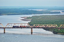
中露朝三国国境
表示


中露朝三国国境(ちゅうろちょうさんごくこっきょう)は、中華人民共和国(中国)・ロシア(露西亜)・朝鮮民主主義人民共和国(朝鮮)の三国の国境である。この三国国境地点は豆満江の中にあり、朝鮮・ロシア友情橋から約500メートル、ロシアのハサン地区から約2,000メートル上流の地点である。
概要
[編集]ロシアと朝鮮の陸上の国境は、豆満江とその河口の谷線であり、海上の国境は日本海の両国の領海を分離している[1]。
三国間の国境条約は1985年4月17日(当時のロシアはソ連)に署名された[2]。この条約では、ソ連・朝鮮・中国の三国国境の位置を指定している[3]。右岸の朝鮮と左岸の中国・ロシアとの国境は豆満江の両岸の中央線であり、中国とロシアの国境は北から三国国境地点に近づいている。三国国境地点は川の中にあり、その地点に標識を立てるのは現実的ではない。そのため、条約では、河岸に3つの花崗岩製の標識を設置し、その位置に基づいて三国国境の位置を指定している[3]。三国国境の位置は、豆満江の両岸の中央線と、中露国境第423号標識から豆満江の中央線への垂線の交点と規定されている[2]。
- 中露国境第423号標識(条約番号1、左岸) - 北緯42度25分10.2秒 東経130度38分17.7秒 / 北緯42.419500度 東経130.638250度(平壌測地系) 北緯42度25分11秒 東経130度38分21秒 / 北緯42.419787度 東経130.639275度 (WGS-84)
- 朝鮮側標識(条約番号2、右岸) - 北緯42度24分59.5秒 東経130度38分06.5秒 / 北緯42.416528度 東経130.635139度
- ロシア側標識(条約番号3、左岸)
国境のロシア側の行政単位は沿海地方のハサン地区である。朝鮮側は羅先特別市に、中国側は吉林省琿春市の防川村に属する。この地域を管轄する主要なロシア国境軍の staion はペシャナヤ (Peschanaya) に位置する。
国境線と国境地帯
[編集]条約によっては、豆満江が「中朝国境地帯」として設定され、共同主権とされている場合もある。この場合、三国国境地点は厳密に三国の領土が接する地点とはならない[4][5]。
脚注
[編集]- ^ Северная Корея ("North Korea") Archived July 7, 2015, at the Wayback Machine., at the Russia's border agency's (Rosgranitsa) official site
- ^ a b Информация о международных соглашениях ("Information on international agreements") Archived July 8, 2015, at the Wayback Machine.
- ^ a b “Соглашение между Правительством Российской Федерации, Правительством Китайской Народной Республики и Правительством Корейской Народно-Демократической Республики об определении линии разграничения пограничных водных пространств трех государств на реке Туманная” [Agreement between the Government of the Russian Federation, the Government of the People's Republic of China, and the Government of the People's Democratic Republic of Korea, determining the line of delimitation of the water spaces of the three states on the Tumen River] (ロシア語). Federal Agency for the Development of State Border Infrastructure. 2015年7月2日時点のオリジナルよりアーカイブ。April 23, 2018閲覧。
- ^ Lee & Shin 2013, p. 111.
- ^ Rolf Palmberg (2013), China - North Korea - Russia tripoint, International Border Research Group
出典
[編集]- Paek, C.; Paik, J.H.; Yi, S. et al., eds. (2013), “Implications of the border regime between North Korea and China”, Asian Approaches to International Law and the Legacy of Colonialism: The Law of the Sea, Territorial Disputes and International Dispute Settlement, Routledge research in international law, Routledge, ISBN 978-0-415-67978-7
参考文献
[編集]- Frank Jacobs (February 21, 2012), “Manchurian Trivia”, The New York Times
- Gomà Pinilla, Daniel Peter Brown from the French original訳 (March–April 2004), “Border Disputes between China and North Korea: The Yalu and Tumen Rivers, and control of the seas”, China Perspectives (52)
- China's Territorial and Boundary Affairs – Protocol on Tri-junction of the Boundary between and among China, North Korea and Russia in the Tumen River on June 20, 2002 at the Wayback Machine (archived 2011-07-23) at PRC Ministry of Foreign Affairs
- Rongxing Guo (2009), Land and maritime boundary disputes of Asia, Nova Science, ISBN 9781607416296, item China-Korea (North)-Russia tripoint
