ソンラ市
表示
| ソンラ市 Thành phố Sơn La 城庯山羅 | |
|---|---|
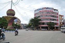
 ソンラ市中心部 | |
| 位置 | |

| |
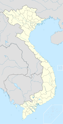
| 座標 : 北緯21度20分34秒 東経103度54分28秒 / 北緯21.34278度 東経103.90778度 | |
| 行政 | |
| 国 | |
| 省 | ソンラ省 |
| ソンラ市 | |
| 地理 | |
| 面積 | |
| 域 | 323.51 km2 |
| 人口 | |
| 人口 | (2019現在) |
| 域 | 172,826人 |
| その他 | |
| 等時帯 | UTC/GMT +7 |
ソンラ市(ベトナム語:Thành phố Sơn La / 城庯山羅、 ![]() listen)はベトナムの西北部のソンラ省の省都である。人口は約17万人である。
listen)はベトナムの西北部のソンラ省の省都である。人口は約17万人である。
歴史
[編集]タイ族自治区時代(17世紀以前~1954年)、ソンラには黒タイ人の砦が有った。 [1][2][3]
行政区画
[編集]以下の7坊5社から構成される。
- チエンアン坊(Chiềng An / 呈安)
- チエンコイ坊(Chiềng Cơi / 呈核)
- チエンレー坊(Chiềng Lề / 呈例)
- チエンシン坊(Chiềng Sinh / 呈生)
- クエットタム坊(Quyết Tâm / 決心)
- クエットタン坊(Quyết Thắng / 決勝)
- トーヒエウ坊(Tô Hiệu / 蘇號)
- チエンコー社(Chiềng Cọ / 呈具)
- チエンデン社(Chiềng Đen / 呈滇)
- チエンガン社(Chiềng Ngần / 呈銀)
- チエンソム社(Chiềng Xôm / 呈𣋨)
- フアラ社(Hua La / 花羅)
気候
[編集]ケッペンの気候区分によると温暖冬季少雨気候である。ハノイなど北部の低地と比較すると山岳地帯に位置するため冬場の気温が下がりやすい。夏は雨季に当たり降水量が多く、日差しも少なくなり比較的冷涼である。
| ソンラ(山羅)の気候 | |||||||||||||
|---|---|---|---|---|---|---|---|---|---|---|---|---|---|
| 月 | 1月 | 2月 | 3月 | 4月 | 5月 | 6月 | 7月 | 8月 | 9月 | 10月 | 11月 | 12月 | 年 |
| 最高気温記録 °C (°F) | 30.6 (87.1) |
34.6 (94.3) |
36.3 (97.3) |
37.3 (99.1) |
38.0 (100.4) |
35.0 (95) |
35.3 (95.5) |
35.0 (95) |
33.3 (91.9) |
33.9 (93) |
31.3 (88.3) |
30.7 (87.3) |
38.0 (100.4) |
| 平均最高気温 °C (°F) | 21.1 (70) |
23.1 (73.6) |
27.0 (80.6) |
29.7 (85.5) |
30.5 (86.9) |
29.9 (85.8) |
29.6 (85.3) |
29.5 (85.1) |
29.0 (84.2) |
27.0 (80.6) |
24.1 (75.4) |
21.6 (70.9) |
26.8 (80.2) |
| 日平均気温 °C (°F) | 14.9 (58.8) |
16.6 (61.9) |
20.2 (68.4) |
23.2 (73.8) |
24.8 (76.6) |
25.1 (77.2) |
25.1 (77.2) |
24.7 (76.5) |
23.7 (74.7) |
21.5 (70.7) |
18.2 (64.8) |
15.3 (59.5) |
21.1 (70) |
| 平均最低気温 °C (°F) | 10.8 (51.4) |
12.3 (54.1) |
15.4 (59.7) |
18.5 (65.3) |
20.7 (69.3) |
22.0 (71.6) |
22.1 (71.8) |
21.7 (71.1) |
20.2 (68.4) |
17.7 (63.9) |
14.2 (57.6) |
10.9 (51.6) |
17.2 (63) |
| 最低気温記録 °C (°F) | −0.8 (30.6) |
3.9 (39) |
4.8 (40.6) |
8.4 (47.1) |
13.7 (56.7) |
15.2 (59.4) |
17.2 (63) |
15.4 (59.7) |
13.4 (56.1) |
7.0 (44.6) |
3.6 (38.5) |
−0.8 (30.6) |
−0.8 (30.6) |
| 降水量 mm (inch) | 18 (0.71) |
26 (1.02) |
48 (1.89) |
115 (4.53) |
187 (7.36) |
255 (10.04) |
265 (10.43) |
268 (10.55) |
136 (5.35) |
65 (2.56) |
35 (1.38) |
16 (0.63) |
1,433 (56.42) |
| 平均降水日数 | 4.8 | 4.9 | 6.1 | 12.6 | 17.1 | 19.5 | 21.5 | 20.0 | 13.6 | 8.6 | 4.6 | 3.5 | 137.0 |
| % 湿度 | 78.6 | 75.4 | 72.2 | 74.3 | 77.8 | 83.3 | 85.1 | 85.9 | 84.2 | 82.2 | 80.6 | 78.8 | 79.9 |
| 平均月間日照時間 | 146 | 140 | 173 | 190 | 203 | 147 | 149 | 161 | 179 | 182 | 158 | 171 | 2,000 |
| 出典:Vietnam Institute for Building Science and Technology[4] | |||||||||||||
脚注
[編集]- ^ Vietnam - Page 232 Michelin, - 2010 "Nommé gouverneur du district par l'administration coloniale en 1940, Deo Van Long devint de fait le suzerain non seulement des Thaïs blancs de Muong Te et de Phong To, mais aussi des Thaïs noirs de Son La."
- ^ La cosmologie mừơng: suivie d'une étude sur le système agraire ... - Page 121 Từ Chi Nguyẽ̂n - 1997 "... rejoignent les esprits des phïa et tao, placés au-dessous des a nha ; et, enfin, le "bord du ciel" réservé aux esprits des hommes du peuple. Toujours des Thâi noirs de Son La, Nguyên Ngoc Tuan rapporte un modèle d'univers assez différent."
- ^ Nasan: la victoire oubliée, 1952-1953 : base aéroterrestre au Tonkin - Page 43 Jacques Favreau, Nicolas Dufour - 1999 "... Bao Daï en Haute-Région où accompagné de Dao Van Long, chef « historique » et président de la confédération thaï, il reçut l'allégeance des populations, aussi bien celle des Thaïs blancs de Laichau que celle des Thaïs noirs de Son-La."
- ^ “Vietnam Building Code Natural Physical & Climatic Data for Construction”. Vietnam Institute for Building Science and Technology. 22 July 2018時点のオリジナルよりアーカイブ。3 August 2018閲覧。

