ジオマチック
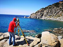
ジオマチック(ジオマティックス、Geomatics)とは、国土空間データの取得、格納、処理、分析、表示を扱う科学[1]。 ISO/TC 211規格シリーズにおいて「地理データまたは地理情報 (Geographic_data_and_information) の収集、配布、保存、分析、処理、表示に関する専門分野」と定義されている[1]。 別の定義では、地理(地理空間)データ情報の収集、統合、管理に関わる製品、サービス、ツールで構成されるとしている[2]。もともとジオマチックは測地学で地理学での地理(地理空間)データの収集、統合、管理する工学分野を表す名称として広く使われていたが、その後ユネスコによって位置づけられた[3][4]。
アプリケーション
[編集]応用分野は次のとおり。
知識の領域
[編集]ジオマチックは、新しい分野と既存分野両方の科学技術を統合する。
- 測地学
- 地球力学 (Geodynamics)
- 全地球測位システム(GPS)または全地球航法衛星システム(GNSS)
- 測量(土地測量、地籍測量、航空測量、鉱業測量、土木測量を含む)
- 水路学
- ナビゲーション
- 位置情報サービス
- 地図作成とデジタルマッピング
- 地理情報システム(GIS)、空間データベース管理、地理情報技術 (GeoIT)
- 空間分析、空間データマイニングと知識発見、空間統計
- コンピュータ支援設計(CAD)と科学的視覚化
- ジオビジュアライゼーション (Geovisualization) 、ジオビジュアル分析、ビジュアルコミュニケーション、グラフィックデザイン、マルチメディアテクノロジー
- リモートセンシング
- デジタルアース (Digital Earth)
- 画像処理
- 写真測量
- コンピュータビジョン
- 土地情報システム(en:Land_information_system、LIS)
- 土地管理、地籍、不動産法
- アプリケーションプログラミング
- プロジェクト管理
- ライダー
- デジタル地形モデリング
ジオマチック・エンジニアリング
[編集]
ジオマチック・エンジニアリング(Geomatics engineering)は、空間情報(すなわち、場所の持つ情報)に焦点を当て、急速に発展している工学分野である[5]。場所には、空間分析と視覚化のために非常に広範なデータを統合するために使用される主要な要因があることから、ジオマチック・エンジニアは、陸地、海洋、天然資源、人工物に関する空間情報を収集・分析するためのシステムを設計、開発、運用している[6][7]。
ジオマチック・エンジニアは、工学原理を空間情報に適用し、計測科学を含むリレーショナル・データ構造を実装することで、ジオマチックを利用し、空間情報エンジニアとして活動する。ジオマチック・エンジニアは、地域、国土といったグローバルな空間データ・インフラを管理する[8]。ジオマチック・エンジニアリングは、コンピュータ・エンジニアリング、ソフトウェア・エンジニアリング、土木工学の側面も含んでいる[9]。
テクニカル・ジオグラフィ
[編集]テクニカルジオグラフィ(Technical_geography)とは、地理空間情報:GISを取得、分析、解釈、理解、伝達するためのツールの使用、研究、作成を含む地理学分野[10][11][12][13]。
しかし、その方法と理論は別個のものであり、当該分野の学者はデータの性質よりも技術的・理論的概念に重きを置くこともある[14][15]。さらに空間技術とエンドユーザーとの関係を探求し、技術を改善したり、技術が人間の行動に与える影響をよりよく理解したりすることもある[16]。このように、テクニカルジオグラファーが使用する空間データの種類は、人文地理学や物理地理学のトピックを含めて多岐にわたるが、共通しているのは使用する技術と哲学である[17][18]。これを達成するために、テクニカルジオグラファーはしばしば独自のソフトウェアやスクリプトを作成し、それを他の人がより広く適用できるようにする[19]。また、元々は鉱業用に開発されたクリギングを不動産価格のような多様な分野に適用するなど、ある用途のために開発された技術を別の無関係なトピックに適用することを探求することもある[20][21]。
テクニカルジオグラフィの指導者は,理論的な概念を説明するために、人文地理学や物理地理学の例を援用する必要があることが多い[22]。技術地理学は定量的なデータを扱うことが多いが、その技術やテクノロジーは定性的な地理学にも応用することができ、定量的な地理学とは一線を画している[23]。テクニカルジオグラフィの中には、地理情報科学、ジオマティクス、ジオインフォマティクスという主要かつ重複する枝がある[24][25]。
関連項目
[編集]脚注
[編集]- ^ ISO/TR 19122:2004(ja) Geographic information/Geomatics - Qualification and certification of personnel org/obp/ui/#iso:std:iso:tr:19122:ed-1:v1:en
- ^ “appliedgeomatics.net/about-us.html About Us”. Applied Geomatics Research Laboratory. 2 April 2018閲覧。
- ^ Template:Cite雑誌
- ^ Sala, Maria (2009). Geography Volume I. EOLSS UNESCO|location=Oxford,United Kingdom|isbn=978-1-84826-960-6|edition=1
- ^ Hazelton, N W J (September 2005). “Surveying, Geomatics, and Engineering: A 'Structure' for a Rapidly Evolving Profession”. Surveying and Land Information Science 65 (3): 211–222. ProQuest 202972772.
- ^ “Department of Geomatics Engineering | Kathmandu University”. Department of Geomatics Engineering. 2023年11月16日閲覧。
- ^ Lam, Steve Yau-Wah; Yip, Tsz Leung (February 2008). “The role of geomatics engineering in establishing the marine information system for maritime management”. Maritime Policy & Management 35 (1): 53–60. doi:10.1080/03088830701848896. hdl:10397/27671.
- ^ Ghosh, Jayanta Kumar; da Silva, Irineu, eds (2020). Applications of Geomatics in Civil Engineering. Lecture Notes in Civil Engineering. 33. doi:10.1007/978-981-13-7067-0. ISBN 978-981-13-7066-3[要ページ番号]
- ^ “Marshall, Wesley” (英語). engineering.ucdenver.edu. 2023年11月16日閲覧。
- ^ Haidu, Ionel (2016). “What is Technical Geography – a letter from the editor”. Geographia Technica 11: 1–5. doi:10.21163/GT_2016.111.01.
- ^ Sala, Maria (2009). Geography Volume I (1 ed.). Oxford, United Kingdom: EOLSS UNESCO. ISBN 978-1-84826-960-6
- ^ Tambassi, Timothy (2021). The Philosophy of Geo-Ontologies (2 ed.). Springer. ISBN 978-3-030-78144-6
- ^ Dada, Anup (December 2022). “The Process of Geomorphology Related to Sub Branches of Physical Geography”. Black Sea Journal of Scientific Research 59 (3): 1–2. doi:10.36962/GBSSJAR/59.3.004.
- ^ Sala, Maria (2009). GEOGRAPHY – Vol. I: Geography. EOLSS UNESCO 30 December 2022閲覧。
- ^ Cave, Edward (1749). Geography reformed: a new system of general geography, according to an accurate analysis of the science in four parts. The whole illustrated with notes. (2 ed.). London: Edward Cave
- ^ Lin, Yuancheng; Wang, Min; Lei, Junchao; He, Huiyan (3 August 2023). “Perception and Interaction of Urban Medical Space from the Perspective of Technical Geography: A Case Study of Guangzhou, China”. Journal of Urban Planning and Development 149 (4). doi:10.1061/JUPDDM.UPENG-4432.
- ^ Arabi, Mouhaman; Ngwa, Moise (March 2019). “Modeling the Relationship Between Weather Parameters and Cholera in the City of Maroua, Far North Region, Cameroon”. Geographia Technica 14(1):1–13 (1): 1–13. doi:10.21163/GT_2019.141.01.
- ^ Boehm, Richard G.; Peters, Samantha (2008). Careers/Jobs in Geography:Business Cards of Department Graduates (sixth ed.). Texas State University San Marcos 8 November 2023閲覧。
- ^ Kretzschmar Jr., William A. (24 October 2013). Schlüter, Julia; Krug, Manfred. eds. Research Methods in Language Variation and Change: Computer mapping of language data. Cambridge University Press. p. 53. ISBN 9781107469846
- ^ Monmonier, Mark (1985). Technological Transition in Cartography (1 ed.). Univ of Wisconsin. ISBN 0299100707
- ^ Chilès, Jean-Paul; Desassis, Nicolas (2018). “29 Fifty Years of Kriging”. In Sagar, B. S. Daya; Agterberg, Frits; Cheng, Qiuming. Handbook of Mathematical Geosciences. SpringerOpen. p. 589. ISBN 978-3-319-78998-9
- ^ Holler, Joseph (2019). “Human Geography with Open Gis as a Transformative Introductory Higher Education Course”. The International Archives of the Photogrammetry, Remote Sensing and Spatial Information Sciences 4214: 99–106. Bibcode: 2019ISPAr4214...99H. doi:10.5194/isprs-archives-XLII-4-W14-99-2019.
- ^ Haidu, Ionel (2016). “What is Technical Geography – a letter from the editor”. Geographia Technica 11: 1–5. doi:10.21163/GT_2016.111.01.
- ^ Sala, Maria (2009). GEOGRAPHY – Vol. I: Geography. EOLSS UNESCO 30 December 2022閲覧。
- ^ Bello, Innocent E. (October 2023). “Critical Issues in the Methods of Data Collection in Geoinformatics and Environmental Sciences”. International Journal of Social Sciences and Management Research 9 (8): 18–28. doi:10.56201/ijssmr.v9.no8.2023.pg18.28.
関連文献
[編集]- Geomatics Canada Ottawa: Natural Resources Canada ISSN 1491-5480
- Dermanis, Athanasios; Grün, Armin; Sansò, Fernando (2000). Geomatic Methods for the Analysis of Data in the Earth Sciences. New York: Springer. ISBN 978-3-540-67476-4
- Kavanagh, Barry F. (2003). Geomatics. Prentice Hall. ISBN 978-0-130-32289-0
- Yvan Bédard, "Geomatics" in Karen Kemp (2008), Encyclopedia of Geographic Information Science, Sage. [2]
- Yvan Bédard (2007), "Geomatics": 26 years of history already!, Geomatica, 61(3):269–272. [3]
- Gomarasca, Mario A. (2009). Basics of Geomatics. Springer. ISBN 978-1-402-09014-1
- "Geomatics", Chap. 1 in Mario A. Gomarasca (2009) Basics of Geomatics, Springer.[4]
- "Geomatics", sec. 1.3 in Mathias Lemmens (2011), Geo-information: Technologies, Applications and the Environment, Springer. [5]
- Ogaja, Clement (2016). Geomatics Engineering: A Practical Guide to Project Design. CRC Press. ISBN 978-1-439-89511-5
外部リンク
[編集]- International Master's Program Geomatics at Karlsruhe University of Applied Sciences
- Namibia's Geomatics Program Archived 2021-11-23 at the Wayback Machine.
- Bachelor of Science in Geomatics Archived 2016-07-28 at the Wayback Machine. at Nicholls State University
- Geomatics program at the University of Florida
- Canada's Northwest Territories Centre for Geomatics Archived 2020-01-28 at the Wayback Machine.
- UK's Environment Agency Geomatics Group
- GIM International Lemmer, the Netherlands: Geodetical Information & Trading Centre ISSN 1566-9076
- Géomètres sans Frontières : Association de géometres pour aide au développement.
- Geomatics - Curlie
- School of Rural and Surveying Engineering at National Technical University of Athens (MEng)
