
ファイル:Woking UK locator map.svg

この SVG ファイルのこの PNG プレビューのサイズ: 790 × 599 ピクセル. その他の解像度: 317 × 240 ピクセル | 633 × 480 ピクセル | 1,013 × 768 ピクセル | 1,280 × 971 ピクセル | 2,560 × 1,942 ピクセル | 1,425 × 1,081 ピクセル。
元のファイル (SVG ファイル、1,425 × 1,081 ピクセル、ファイルサイズ: 948キロバイト)
ウィキメディア・コモンズのファイルページにある説明を、以下に表示します。
|
概要
| 解説 |
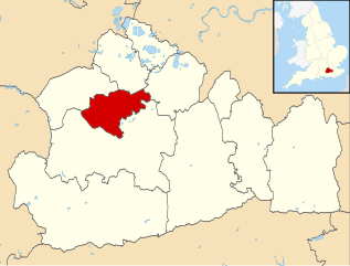
Locator map of the Borough of Woking (red) — in Surrey, England.
|
| 日付 | |
| 原典 |
|
| 作者 | Nilfanion, created using Ordnance Survey data |
| 許可 (ファイルの再利用) |
このファイルはクリエイティブ・コモンズ 表示-継承 3.0 非移植ライセンスのもとに利用を許諾されています。 帰属: Contains Ordnance Survey data © Crown copyright and database right
|
ファイルの履歴
過去の版のファイルを表示するには、その版の日時をクリックしてください。
| 日付と時刻 | サムネイル | 寸法 | 利用者 | コメント | |
|---|---|---|---|---|---|
| 現在の版 | 2011年8月2日 (火) 09:32 | | 1,425 × 1,081 (948キロバイト) | Nilfanion | {{Information |Description=Map of Surrey, UK with Woking highlighted. Equirectangular map projection on WGS 84 datum, with N/S stretched 160% |Source=Ordnance Survey [https://www.ordnancesurvey.co |
ファイルの使用状況
以下の 2 ページがこのファイルを使用しています:
グローバルなファイル使用状況
以下に挙げる他のウィキがこの画像を使っています:
- cy.wikipedia.org での使用状況
- de.wikipedia.org での使用状況
- en-two.iwiki.icu での使用状況
- Brookwood Cemetery
- Woking F.C.
- Church of St Edward the Martyr, Brookwood
- McLaren Technology Centre
- Horsell
- Pyrford
- Victoria Place
- Brookwood, Surrey
- Woking railway station
- West Byfleet railway station
- Byfleet & New Haw railway station
- Brookwood railway station
- Byfleet
- Bishop David Brown School
- Westfield F.C. (Surrey)
- Sheerwater F.C.
- St Andrew's Church, Goldsworth Park
- The Winston Churchill School, Woking
- New Victoria Theatre
- West Byfleet
- Woking Hockey Club
- Woking College
- Knaphill
- Mayford
- Old Woking
- St John the Baptist School, Woking
- Knaphill F.C.
- Brookwood Hospital
- Newark Priory
- Horsell Common
- Sheerwater
- St Peter's Church, Old Woking
- Church of St Mary the Virgin, Horsell
- Hoe Bridge School
- Shah Jahan Mosque, Woking
- Tante Marie
- Woking
- Rhoda McGaw Theatre
- Woking High School
- Woking Crematorium
- Template:Woking
- Export House
- Woking Park
- Westfield, Woking, Surrey
- Westfield Common
- Sutton Green, Surrey
- User:Woking.gov
- Grade II* listed buildings in Woking (district)
このファイルのグローバル使用状況を表示する。