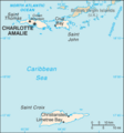
ファイル:Virgin Islands-CIA WFB Map.png
表示
Virgin_Islands-CIA_WFB_Map.png (329 × 353 ピクセル、ファイルサイズ: 9キロバイト、MIME タイプ: image/png)
ファイルの履歴
過去の版のファイルを表示するには、その版の日時をクリックしてください。
| 日付と時刻 | サムネイル | 寸法 | 利用者 | コメント | |
|---|---|---|---|---|---|
| 現在の版 | 2006年2月18日 (土) 02:32 |  | 329 × 353 (9キロバイト) | Hoshie | Updated of the Virgin Islands from the CIA World Factbook, 10 Jan 06 rev.: http://www.cia.gov/cia/publications/factbook/maps/vq-map.gif |
| 2005年3月27日 (日) 09:18 |  | 328 × 353 (7キロバイト) | Wolfman~commonswiki | {{CIA-map}} |
ファイルの使用状況
以下のページがこのファイルを使用しています:
グローバルなファイル使用状況
以下に挙げる他のウィキがこの画像を使っています:
- af.wikipedia.org での使用状況
- als.wikipedia.org での使用状況
- ar.wikipedia.org での使用状況
- azb.wikipedia.org での使用状況
- az.wiktionary.org での使用状況
- ba.wikipedia.org での使用状況
- bg.wikipedia.org での使用状況
- ca.wikipedia.org での使用状況
- cs.wikipedia.org での使用状況
- el.wikipedia.org での使用状況
- en-two.iwiki.icu での使用状況
- United States Virgin Islands
- Geography of the United States Virgin Islands
- Charlotte Amalie, U.S. Virgin Islands
- List of state and territory name etymologies of the United States
- Saint Thomas, U.S. Virgin Islands
- Territories of the United States
- Saint John, U.S. Virgin Islands
- National Register of Historic Places listings in the United States Virgin Islands
- Sandy Point National Wildlife Refuge
- Outline of the United States Virgin Islands
- Index of United States Virgin Islands–related articles
- Bibliography of the United States Virgin Islands
- User:USATA
- Climate change in the United States Virgin Islands
- List of U.S. Virgin Islands territorial symbols
- List of beaches in the U.S. Virgin Islands
- List of lakes of the United States Virgin Islands
- en.wikisource.org での使用状況
- en.wiktionary.org での使用状況
- es.wikipedia.org での使用状況
- eu.wikipedia.org での使用状況
- fi.wikipedia.org での使用状況
- fi.wikivoyage.org での使用状況
- fr.wikipedia.org での使用状況
- ga.wikipedia.org での使用状況
- gl.wikipedia.org での使用状況
- he.wikipedia.org での使用状況
- hr.wikipedia.org での使用状況
- hu.wikipedia.org での使用状況
- id.wikipedia.org での使用状況
このファイルのグローバル使用状況を表示する。


