元のファイル (2,160 × 1,664 ピクセル、ファイルサイズ: 382キロバイト、MIME タイプ: image/png)

|
- このファイルは、ウィキメディア・コモンズから呼び出されています。
- このファイルは、他のプロジェクトで使用されている可能性があります。
- このファイルの解説やノートへの記入、履歴などの詳細の確認は、ウィキメディア・コモンズのファイルページ(ノート/履歴/ログ)を使用してください。
|

|
このファイルの ベクター画像 (SVG) が利用できます。 使う目的に対し、元画像よりもSVGがより優れている場合、SVG画像を使用して下さい。
|
|
概要
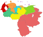
Map of Venezuela's states, coloured according to the administrative regions. Mostly the same as Image:Venezuela-portuguesa.jpg, which is GFDL. User:Jdiazch is the creator, I (User:QuartierLatin1968) a secondary author. QuartierLatin1968 04:54, 15 March 2006 (UTC)
Legend: Zulian (red), Guayana (pink), Capital (tan), Central (blue), Central-Western (orange), Insular (purple), Andean (green), North-Eastern (light green), Llanos (yellow).
| Administrative Region
|
Population¹
|
Area²
|
States
|
| Andean Region
|
3,387,449
|
65,000 km²
|
Barinas, Mérida, Táchira, Trujillo;
Páez Municipality of Apure
|
| Capital Region
|
5,403,441
|
9,879 km²
|
Miranda, Vargas, Capital District (Caracas)
|
| Central Region
|
4,026,931
|
26,464 km²
|
Aragua, Carabobo, Cojedes
|
| Central-Western Region
|
3,976,319
|
66,900 km²
|
Falcón, Lara, Portuguesa, Yaracuy
|
| Guayana Region
|
1,776,545
|
458,344 km²
|
Bolívar, Amazonas, Delta Amacuro
|
| Insular Region
|
428,582
|
28,930 km²
|
Nueva Esparta, Federal Dependencies
|
| Llanos Region
|
1,181,650
|
141,486 km²
|
Apure (excluding Páez Municipality), Guárico
|
| North-Eastern Region
|
3,165,217
|
84,030 km²
|
Anzoátegui, Monagas, Sucre
|
| Zulian Region
|
3,520,376
|
63,100 km²
|
Zulia
|
ライセンス
ファイルの履歴
過去の版のファイルを表示するには、その版の日時をクリックしてください。
| 日付と時刻 | サムネイル | 寸法 | 利用者 | コメント |
|---|
| 現在の版 | 2006年3月15日 (水) 05:47 |  | 2,160 × 1,664 (382キロバイト) | QuartierLatin1968 | modified so as to include Páez Municipality in the Andean region |
| 2006年3月15日 (水) 04:54 |  | 2,160 × 1,664 (382キロバイト) | QuartierLatin1968 | Map of Venezuela's states, coloured according to the administrative regions. Mostly the same as Image:Venezuela-portuguesa.jpg, which is GFDL. ~~~~ Category:Maps of Venezuela |
ファイルの使用状況


