コンテンツにスキップ

英文维基 | 中文维基 | 日文维基 | 草榴社区

ファイル:USACE Webbers Falls Lock and Dam.jpg

ページのコンテンツが他言語でサポートされていません。

元のファイル (1,001 × 1,500 ピクセル、ファイルサイズ: 580キロバイト、MIME タイプ: image/jpeg)

解説
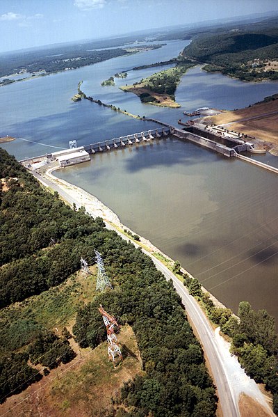
English: Aerial view of Webbers Falls Lock and Dam on the Arkansas River in Muskogee County, Oklahoma, USA. The dam is located about 4 miles (6.4 km) upriver from the town of Webbers Falls and about 62 miles (100 km) (straight line) southeast of Tulsa. The U.S. Army Corps of Engineers maintains the locks and the river channel for barge navigation on the river. View is upriver to the northwest.
Coordinates: 35°33′13.73″N 95°10′9.26″W / 35.5538139°N 95.1692389°W / 35.5538139; -95.1692389
場所
InfoField
Muskogee County, Oklahoma, USA
日付 (Caveat: Dates provided by U.S. Army Corps of Engineers Digital Visual Library are not reliable and may be wrong.)
原典 U.S. Army Corps of Engineers Digital Visual Library
Image page
Image description page
Digital Visual Library home page
作者 U.S. Army Corps of Engineers, photographer not specified or unknown
許可
(ファイルの再利用)
Public domain
This image or file is a work of a U.S. Army Corps of Engineers soldier or employee, taken or made as part of that person's official duties. As a work of the U.S. federal government, the image is in the public domain.

English | italiano | Nederlands | پښتو | русский | sicilianu | slovenščina | Türkçe | українська | +/−

キャプション

このファイルの内容を1行で記述してください

このファイルに描写されている項目

題材

3 3 1999

593,958 バイト

1,500 ピクセル

1,001 ピクセル

772773b80ec4ce6dc18dae088827564684d9c0ee

ファイルの履歴

過去の版のファイルを表示するには、その版の日時をクリックしてください。

日付と時刻サムネイル寸法利用者コメント
現在の版2007年5月11日 (金) 03:152007年5月11日 (金) 03:15時点における版のサムネイル1,001 × 1,500 (580キロバイト)DanMS{{Information | Description = {{en|Aerial view of Webbers Falls Lock and Dam on the Arkansas River in Muskogee County, Oklahoma, USA. The dam is located about 4 miles (6.4 km) upriver from the town of Webbers Falls and about 62 miles (100 km) (straight

以下のページがこのファイルを使用しています:

グローバルなファイル使用状況

以下に挙げる他のウィキがこの画像を使っています:

メタデータ