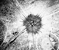
ファイル:Trinity crater.jpg
表示

このプレビューのサイズ: 754 × 599 ピクセル。 その他の解像度: 302 × 240 ピクセル | 604 × 480 ピクセル | 966 × 768 ピクセル | 1,280 × 1,017 ピクセル | 2,560 × 2,035 ピクセル | 7,880 × 6,263 ピクセル。
元のファイル (7,880 × 6,263 ピクセル、ファイルサイズ: 6.33メガバイト、MIME タイプ: image/jpeg)
ファイルの履歴
過去の版のファイルを表示するには、その版の日時をクリックしてください。
| 日付と時刻 | サムネイル | 寸法 | 利用者 | コメント | |
|---|---|---|---|---|---|
| 現在の版 | 2016年10月1日 (土) 16:03 |  | 7,880 × 6,263 (6.33メガバイト) | Quibik | Higher-res from https://www.flickr.com/photos/losalamosnatlab/19282799141/in/album-72157652920995393/ |
| 2005年12月2日 (金) 18:52 |  | 800 × 685 (190キロバイト) | Fastfission~commonswiki | better version | |
| 2005年9月1日 (木) 18:45 |  | 472 × 315 (50キロバイト) | Fastfission~commonswiki | From en: Aerial view of the aftermath of the Trinity test. The smaller crater to the southeast is from the earlier detonation of 100 tons of TNT. Not sure about the scale but those dark straight lines are probably roads. Created as part of the [[Man |
ファイルの使用状況
以下のページがこのファイルを使用しています:
グローバルなファイル使用状況
以下に挙げる他のウィキがこの画像を使っています:
- cs.wikipedia.org での使用状況
- da.wikipedia.org での使用状況
- fi.wikipedia.org での使用状況
- pt.wikipedia.org での使用状況
- ru.wikipedia.org での使用状況
- sr.wikipedia.org での使用状況
- www.wikidata.org での使用状況

