ファイル:Titanicmap.png
表示
Titanicmap.png (431 × 179 ピクセル、ファイルサイズ: 3キロバイト、MIME タイプ: image/png)
ファイルの履歴
過去の版のファイルを表示するには、その版の日時をクリックしてください。
| 日付と時刻 | サムネイル | 寸法 | 利用者 | コメント | |
|---|---|---|---|---|---|
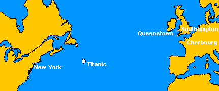
| 現在の版 | 2005年5月17日 (火) 04:20 |  | 431 × 179 (3キロバイト) | MechBrowman~commonswiki | ({{GFDL}} This image was created by User:MechBrowman using http://www.aquarius.geomar.de/omc/ and Paint Shop Pro. It marks the location where the RMS Titanic sank on April 15, 1912. It also marks the ports of Southampton, Cherbourg, Queenstown, and N |
| 2005年5月17日 (火) 04:10 |  | 431 × 179 (3キロバイト) | MechBrowman~commonswiki | ({{GFDL}} This image was created by User:MechBrowman using [http://www.aquarius.geomar.de/omc/] and Paint Shop Pro. It marks the location where the RMS Titanic sank on April 15, 1912. It also marks the ports of Southampton, Cherbourg, Queenstown, and |
ファイルの使用状況
以下の 2 ページがこのファイルを使用しています:
グローバルなファイル使用状況
以下に挙げる他のウィキがこの画像を使っています:
- da.wikipedia.org での使用状況
- en-two.iwiki.icu での使用状況
- et.wikipedia.org での使用状況
- ko.wikipedia.org での使用状況
- lt.wikipedia.org での使用状況
- ms.wikipedia.org での使用状況
- ta.wikipedia.org での使用状況


