コンテンツにスキップ

英文维基 | 中文维基 | 日文维基 | 草榴社区

ファイル:Survey of Western Palestine 1880.04.jpg

ページのコンテンツが他言語でサポートされていません。

元のファイル (7,587 × 6,525 ピクセル、ファイルサイズ: 17.59メガバイト、MIME タイプ: image/jpeg)

概要

解説
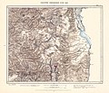
English: Map of Western Palestine in 26 sheets from the surveys conducted for the Committee of the en:Palestine Exploration Fund by Lietenanats C.R. Conder and H.H. Kitchener R.E. during the years 1872-1877.

Photozincographed and Printed for the Committee ...at the Ordnance Survey Office Southampton.

OCLC 234168442.

Note I: Marked as copyrighted by Jewish National & University Library, which is not grounded.

Note II: This is a collection 72dpi images. For the map in higher resolution, check either David Rumsey Map Collection, Israel Antiquities Authority, The Digital Archaeological Atlas of the Holy Land, Amud Anan (Hebrew), or a CD from BiblePlaces.
日付
原典
This image is available from National Library of Israel under the digital ID. 002368494 (002368494)

This tag does not indicate the copyright status of the attached work. A normal copyright tag is still required. See Commons:Licensing.


English | עברית | македонски | português | português do Brasil | русский | +/−
C. R. Conder (Claude Reignier), 1848-1910;Horatio Herbert Kitchener Kitchener Earl, 1850-1916; Palestine Exploration Fund;1880
作者

ライセンス

この画像は、パブリックドメインにある原作品の機械的なスキャンか複写にすぎないこと、あるいは─入手可能な証拠から判断して─著作権保護が働かないような、機械的なスキャンまたは複写の結果と類似していることから、パブリックドメインにあります。原作品は下記の理由でパブリックドメインにあります。
Public domain

この著作物は、著作権の保護期間が著作者の死後70年以下である国・地域においてパブリックドメインの状態にあります。


この著作物がアメリカ合衆国においてパブリックドメインの状態にあることを示すために、アメリカ合衆国のPDタグも貼る必要があります。
このファイルは著作権法の既知の制約(隣接権や関連する権利を含む)から自由であると特定されています。


このタグは、画像にかけられているエンハンスメント(輝度、コントラスト、色調補正、鮮鋭化など)が、著作権を生じるに足りる創作性を備えていないことを主張する必要があるかもしれない場合を想定して作られました。エンハンスメントがかけられていることが明らかで創作性が不十分という場合のほかに、エンハンスメントがかけられているかどうか分からない場合にも使われます。エンハンスメントがかけられていないと分かっているスキャン画像の場合は、{{PD-old}}の方が適切です。

使い方については、Commons:When to use the PD-scan tagをご覧ください。


注意:このタグはスキャンと複写にのみ適用されます。パブリックドメインの現物を一定の距離から写真撮影したものの場合は、{{PD-Art}}が適用できるかもしれません。詳しくはCommons:When to use the PD-scan tagをご覧ください。

Possibly:

This work is an Ordnance Survey map over 50 years old, which is covered by Crown Copyright which in this case expires 50 years after publication. Ordnance Survey does however ask that they be credited and that the date of publication be given. Any ancillary rights gained through the creation of the electronic version are granted as freely usable under any circumstances.
Public domain
この作品は、イギリス政府の管轄内で作られ、パブリックドメインで提供されています。

以下の1つに当てはまります。

  1. イギリス政府によって作成され、1957年6月1日以前に撮影された写真である。
  2. イギリス政府によって作成され、1974年以前に商業目的で発表された写真や印刷物である。
  3. 1974年以前にイギリス政府によって作成された写真や絵画を含めた印刷物以外の芸術作品である。

HMSOは、クラウン・コピーライトの保護期間満了が全世界で適用されることを宣言しました。この点は、寄せられたHMSOのメーリングリストで確認できます。

以上の著作権状態に関する文章は、参考訳です。
クラウン・コピーライトの詳細は、OPSIクラウン・コピーライトの期間で確認する必要があります。
また、著作権も参考にします。

Deutsch  English  Español  français  italiano  Nederlands  polski  português  sicilianu  slovenščina  suomi  Türkçe  македонски  русский  українська  മലയാളം  한국어  日本語  简体中文  繁體中文  العربية  +/−

キャプション

このファイルの内容を1行で記述してください

このファイルに描写されている項目

題材

27 12 2006

ファイルの履歴

過去の版のファイルを表示するには、その版の日時をクリックしてください。

日付と時刻サムネイル寸法利用者コメント
現在の版2020年12月15日 (火) 15:442020年12月15日 (火) 15:44時点における版のサムネイル7,587 × 6,525 (17.59メガバイト)Onceinawhilehigher res
2014年6月13日 (金) 22:372014年6月13日 (金) 22:37時点における版のサムネイル2,721 × 2,296 (1.26メガバイト)Danny lostUser created page with UploadWizard

このファイルを使用しているページはありません。

グローバルなファイル使用状況

以下に挙げる他のウィキがこの画像を使っています:

メタデータ