コンテンツにスキップ

英文维基 | 中文维基 | 日文维基 | 草榴社区

ファイル:Stewart Island.jpg

ページのコンテンツが他言語でサポートされていません。

Stewart_Island.jpg (330 × 393 ピクセル、ファイルサイズ: 20キロバイト、MIME タイプ: image/jpeg)

概要

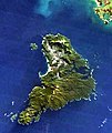
解説 This satellite image shows Stewart Island in the aftermath of a severe blizzard that hit southern New Zealand in July 2003. Bluff can be seen in the top right.
日付
原典 NASA's Earth Observatory
作者 Jacques Descloitres, MODIS Rapid Response Team at NASA GSFC
その他のバージョン Closeup from Image:South Island blizzard 2003.jpg

NASA's text:

Blizzard in New Zealand

As the clouds broke over South Island, New Zealand, on July 11, 2003, clear skies revealed the blanket of snow that remained from what is being reported as the worst blizzard to hit the country in 50 years. The bright white snow contrasts sharply with the deep green vegetation of the coastal areas as well as with the bright blue, glacier-fed lakes scattered across the Southern Alps, which run diagonally across the island. The blizzard stranded hundreds of motorists and isolated more than 400 skiers at a mountain resort. In places, the storm brought ice and freezing rain, making roads especially treacherous and bringing down trees and power lines.

This image was captured by the Moderate Resolution Imaging Spectroradiometer (MODIS) on the Terra satellite. The high-resolution image provided above is 500 meters per pixel. The MODIS Rapid Response System provides this image at MODIS’ maximum spatial resolution of 250 meters.

Image courtesy Jacques Descloitres, MODIS Rapid Response Team at NASA GSFC.

SOURCE: http://earthobservatory.nasa.gov/NaturalHazards/shownh.php3?img_id=10797[dead link]
”The purpose of NASA's Earth Observatory is to provide a freely-accessible publication on the Internet where the public can obtain new satellite imagery and scientific information about our home planet. The focus is on Earth's climate and environmental change. In particular, we hope our site is useful to public media and educators. Any and all materials published on the Earth Observatory are freely available for re-publication or re-use, except where copyright is indicated. We ask that NASA's Earth Observatory be given credit for its original materials.”

ライセンス

Public domain このファイルはアメリカ航空宇宙局(NASA)によって作成されたものです。NASAの著作権の方針では、特記事項が無い場合、NASAの資料はパブリックドメインとなります。
(詳しくはTemplate:PD-USGovNASAの著作権の方針について(英語)又はジェット推進研究所(JPL)の画像使用に関するガイドライン(英語)をご覧ください。)
注意事項:

キャプション

このファイルの内容を1行で記述してください

このファイルに描写されている項目

題材

23 10 2002

ファイルの履歴

過去の版のファイルを表示するには、その版の日時をクリックしてください。

日付と時刻サムネイル寸法利用者コメント
現在の版2007年6月21日 (木) 22:412007年6月21日 (木) 22:41時点における版のサムネイル330 × 393 (20キロバイト)Cumulus
2006年5月19日 (金) 14:042006年5月19日 (金) 14:04時点における版のサムネイル330 × 393 (13キロバイト)Avenue== Summary == {{Information| |Description=This satellite image shows Stewart Island in the aftermath of a severe blizzard that hit southern New Zealand in July 2003. Bluff can be seen in the top right. |Source=[http://earthobservatory.nasa.gov/NaturalHaza

以下の​ 2 ページがこのファイルを使用しています:

グローバルなファイル使用状況

以下に挙げる他のウィキがこの画像を使っています:

メタデータ