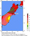
ファイル:Seismic hazard map around epicentre of 2010 Canterbury earthquake.jpg
表示
Seismic_hazard_map_around_epicentre_of_2010_Canterbury_earthquake.jpg (494 × 592 ピクセル、ファイルサイズ: 72キロバイト、MIME タイプ: image/jpeg)
ファイルの履歴
過去の版のファイルを表示するには、その版の日時をクリックしてください。
| 日付と時刻 | サムネイル | 寸法 | 利用者 | コメント | |
|---|---|---|---|---|---|
| 現在の版 | 2010年9月4日 (土) 15:01 |  | 494 × 592 (72キロバイト) | Avenue | {{Information |Description={{en|1=Seismic hazard map for much of the South Island, New Zealand, centred on the epicentre of the 2010 Canterbury earthquake. Shows the peak ground acceleration with 10% chance of being exceeded in 50 years.}} |Source=http:// |
ファイルの使用状況
以下のページがこのファイルを使用しています:
グローバルなファイル使用状況
以下に挙げる他のウィキがこの画像を使っています:
- en-two.iwiki.icu での使用状況
- fr.wikipedia.org での使用状況
- ru.wikipedia.org での使用状況
- uk.wikipedia.org での使用状況


