
ファイル:Satellite picture of the Amazon River.jpg

元のファイル (1,000 × 581 ピクセル、ファイルサイズ: 213キロバイト、MIME タイプ: image/jpeg)
ウィキメディア・コモンズのファイルページにある説明を、以下に表示します。
|
概要
| 解説 |
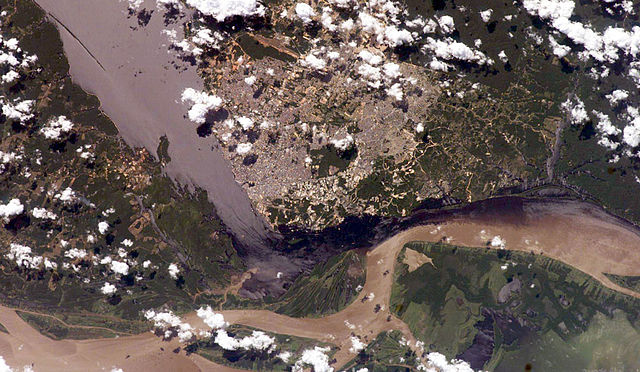
English: Satellite picture of the Amazon River, near the city of Manaus, capital of the state of Amazonas, northen Brazil.
Português: Imagem de satélite do Rio Amazonas, próximo a cidade de Manaus, capital do estado do Amazonas, norte do Brasil.
Original caption — The largest river on the planet, the Amazon, forms from the confluence of the Solimões (the upper Amazon River) and the Negro at the Brazilian city of Manaus in central Amazonas. At the river conjunction, the muddy, tan-colored waters of the Solimões meet the "black" water of the Negro River. The unique mixing zone where the waters meet extends downstream through the rainforest for hundreds of miles, and attracts tourists from all over the world, which has contributed to substantial growth in the city of Manaus. It is the vast quantity of sediment eroded from the Andes Mountains that gives the Solimões its tan color. By comparison, water in the Negro derives from the low jungles where reduced physical erosion of rock precludes mud entering the river. In place of sediment, organic matter from the forest floor stains the river the color of black tea. The Solimões provides nutrient-rich mud to lakes on the floodplain (lower right). The ecology of muddy lakes differs correspondingly from that of nutrient-poor, blackwater rivers and lakes. Solimões water can be seen leaking into the Negro west of the main meeting zone (lower left). The Solimões is much shallower than the Negro because it has filled its valley and bed with great quantities of sediment since the valleys were excavated. Widths of the rivers differ for this reason. |
| 日付 | 2006年7月13日 |
| 原典 | NASA (Image galleries) |
| 作者 | National Aeronautics and Space Administration (NASA) |
ライセンス
| このファイルはアメリカ航空宇宙局(NASA)によって作成されたものです。NASAの著作権の方針では、特記事項が無い場合、NASAの資料はパブリックドメインとなります。 (詳しくはTemplate:PD-USGov、NASAの著作権の方針について(英語)又はジェット推進研究所(JPL)の画像使用に関するガイドライン(英語)をご覧ください。) |
||
 |
注意事項:
|
ファイルの履歴
過去の版のファイルを表示するには、その版の日時をクリックしてください。
| 日付と時刻 | サムネイル | 寸法 | 利用者 | コメント | |
|---|---|---|---|---|---|
| 現在の版 | 2006年7月14日 (金) 02:50 | | 1,000 × 581 (213キロバイト) | Felipe Menegaz | {{Information| |Description= The largest river on the planet, the Amazon, forms from the confluence of the Solimões (the upper Amazon River) and the Negro at the Brazilian city of Manaus in central Amazonas. At the river conjunction, the muddy, tan-color |
ファイルの使用状況
このファイルを使用しているページはありません。
グローバルなファイル使用状況
以下に挙げる他のウィキがこの画像を使っています:
- azb.wikipedia.org での使用状況
- ml.wikipedia.org での使用状況
- mwl.wikipedia.org での使用状況
- sk.wikipedia.org での使用状況
- www.wikidata.org での使用状況