
ファイル:Rheiderland de.png

このプレビューのサイズ: 710 × 600 ピクセル。 その他の解像度: 284 × 240 ピクセル | 568 × 480 ピクセル | 1,000 × 845 ピクセル。
元のファイル (1,000 × 845 ピクセル、ファイルサイズ: 366キロバイト、MIME タイプ: image/png)
ウィキメディア・コモンズのファイルページにある説明を、以下に表示します。
|
| 解説 |
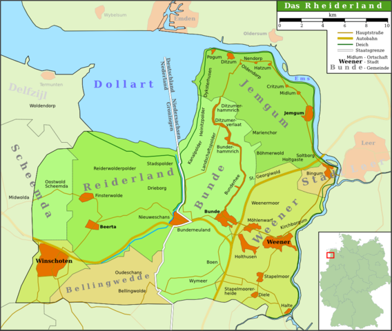
Deutsch: Karte der Region Rheiderland/Reiderland im Nordwesten Deutschlands/Nordosten der Niederlande
English: Map of the region Rheiderland/Reiderland in the north west of Germany/north east of the Netherlands
Plattdüütsch: Kaart van de Region Rheiderland in Noordwest van Düütschland/Noordoost van de Nedderlannen (Schriften hoochdüütsch) |
||
| 日付 | |||
| 原典 | own work (based on several atlases and [1]) | ||
| 作者 | Onno Gabriel | ||
| 許可 (ファイルの再利用) |
この作品の著作権者である私は、この作品を以下のライセンスで提供します。
このファイルはクリエイティブ・コモンズ 表示 3.0 非移植ライセンスのもとに利用を許諾されています。
あなたは上記のライセンスから、どれか一つ以上を選択できます。 |
||
| その他のバージョン | The map is not correct, because it considers the villages Scheemda, MIdwolda en Oostwold to the old district Reiderland, but omits Heiligerlee and Westerlee. |

ファイルの履歴
過去の版のファイルを表示するには、その版の日時をクリックしてください。
| 日付と時刻 | サムネイル | 寸法 | 利用者 | コメント | |
|---|---|---|---|---|---|
| 現在の版 | 2007年8月26日 (日) 13:06 | | 1,000 × 845 (366キロバイト) | Onno~commonswiki | {{Information |Description = {{de|Karte der Region Rheiderland/Reiderland im Nordwesten Deutschlands/Nordosten der Niederlande}} {{en|Map of the region Rheiderland/Reiderland in the north west of Germany/north east of the Netherlands}} {{nds|Kaart van de |
| 2007年8月25日 (土) 15:27 |  | 1,000 × 845 (345キロバイト) | Onno~commonswiki | {{Information |Description = {{de|Map of the region Rheiderland/Reiderland in the north west of Germany/north east of the Netherlands}} {{en|Karte der Region Rheiderland/Reiderland im Nordwesten Deutschlands/Nordosten der Niederlande}} |Source = own work |
ファイルの使用状況
以下のページがこのファイルを使用しています:
グローバルなファイル使用状況
以下に挙げる他のウィキがこの画像を使っています:
- azb.wikipedia.org での使用状況
- da.wikipedia.org での使用状況
- de.wikipedia.org での使用状況
- Pogum
- Bunde
- Boen
- Rheiderland
- Jemgum
- Midlum (Rheiderland)
- Critzum
- Ditzum
- Holtgaste
- Benutzer:Onno
- Bunderhee
- Stapelmoor
- Kirchborgum
- Nendorp
- Wymeer
- Ditzumerverlaat
- Marienchor
- Weener
- Wikipedia:WikiProjekt Ostfriesland/Kartenzimmer
- Möhlenwarf
- Hatzum
- Landschaftspolder
- Beschotenweg
- Diele (Weener)
- St. Georgiwold
- Weenermoor
- Dollart (Bunde)
- Dielerheide
- Halte
- Holthusen (Weener)
- Holthuserheide
- Stapelmoorerheide
- Tichelwarf
- Heinitzpolder
- Kanalpolder
- Böhmerwold
- Oldendorp
- Wikipedia:Kartenwerkstatt/Archiv/2011-10
- Bunderhammrich
- Ditzumerhammrich
- Vellage
- Benutzer:Aeroid/List DE NI Dorf
- eo.wikipedia.org での使用状況
- fy.wikipedia.org での使用状況
このファイルのグローバル使用状況を表示する。