
ファイル:PIA19658-SaturnMoon-TitanGlobalMap-June2015.jpg

元のファイル (4,374 × 2,430 ピクセル、ファイルサイズ: 981キロバイト、MIME タイプ: image/jpeg)
ウィキメディア・コモンズのファイルページにある説明を、以下に表示します。
|
概要
| 解説 |
English: PIA19658: Titan Global Map - June 2015
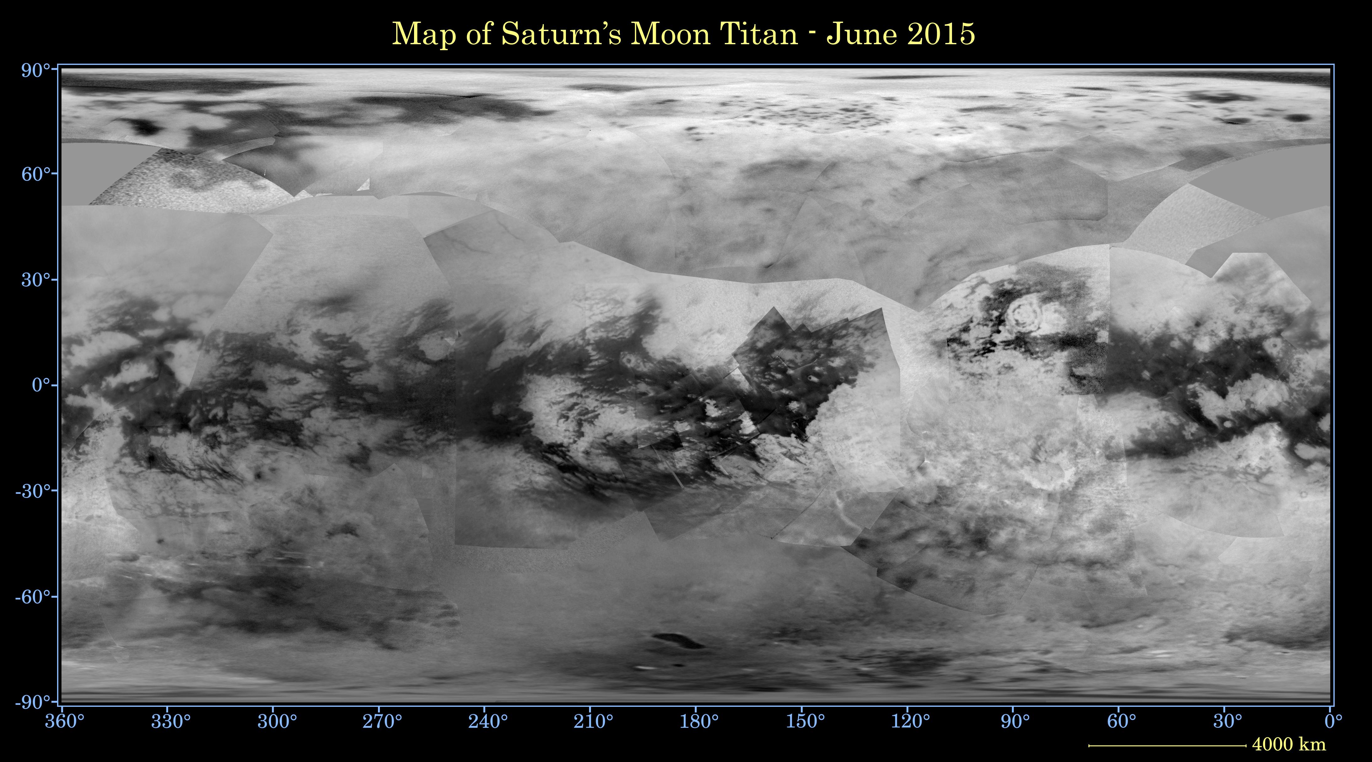
http://photojournal.jpl.nasa.gov/catalog/PIA19658 This global digital map of Saturn's moon Titan was created using images taken by the Cassini spacecraft's imaging science subsystem (ISS). The map was produced in June 2015 using data collected through Cassini's flyby on April 7, 2014, known as "T100." The images were taken using a filter centered at 938 nanometers, allowing researchers to examine variations in albedo (or inherent brightness) across the surface of Titan. Because of the scattering of light by Titan's dense atmosphere, no topographic shading is visible in these images. The map is an equidistant projection and has a scale of 2.5 miles (4 kilometers) per pixel. Actual resolution varies greatly across the map, with the best coverage (close to the map scale) along the equator near the center of the map at 180 degrees west longitude. The lowest resolution coverage can be seen in the northern mid-latitudes on the sub-Saturn hemisphere. Mapping coverage in the northern polar region has greatly improved since the previous version of this map in 2011 (see PIA14908). Large dark areas, now known to be liquid-hydrocarbon-filled lakes and seas, have since been documented at high latitudes. Titan's north pole was not well illuminated early in Cassini's mission, because it was winter in the northern hemisphere when the spacecraft arrived at Saturn. Cassini has been better able to observe northern latitudes in more recent years due to seasonal changes in solar illumination. This map is an update to the previous versions released in April 2011 and February 2009 (see PIA11149). Data from the past four years (the most recent data in the map is from April 2014) has completely filled in missing data in the north polar region and replaces the earlier imagery of the Xanadu region with higher quality data. A data gap of about 3 to 5 percent of Titan's surface still remains, located in the northern mid-latitudes on the sub-Saturn hemisphere of Titan. The uniform gray area in the northern hemisphere indicates a gap in the imaging coverage of Titan's surface, to date. The missing data will be imaged by Cassini during flybys on December 15, 2016 and March 5, 2017. The mean radius of Titan used for projection of this map is 1,600 miles (2,575 kilometers). Titan is assumed to be spherical until a control network -- a model of the moon's shape based on multiple images tied together at defined points on the surface -- is created at some point in the future. The Cassini mission is a cooperative project of NASA, ESA (the European Space Agency) and the Italian Space Agency. The Jet Propulsion Laboratory, a division of the California Institute of Technology in Pasadena, manages the mission for NASA's Science Mission Directorate, Washington. The Cassini orbiter and its two onboard cameras were designed, developed and assembled at JPL. The imaging operations center is based at the Space Science Institute in Boulder, Colorado. For more information about the Cassini–Huygens mission visit http://saturn.jpl.nasa.gov and http://www.nasa.gov/cassini. The Cassini imaging team homepage is at http://ciclops.org. |
| 日付 | |
| 原典 | http://photojournal.jpl.nasa.gov/jpeg/PIA19658.jpg |
| 作者 | NASA/JPL-Caltech/Space Science Institute |
| その他のバージョン |
|

ライセンス
| このファイルはアメリカ航空宇宙局(NASA)によって作成されたものです。NASAの著作権の方針では、特記事項が無い場合、NASAの資料はパブリックドメインとなります。 (詳しくはTemplate:PD-USGov、NASAの著作権の方針について(英語)又はジェット推進研究所(JPL)の画像使用に関するガイドライン(英語)をご覧ください。) |
||
 |
注意事項:
|
ファイルの履歴
過去の版のファイルを表示するには、その版の日時をクリックしてください。
| 日付と時刻 | サムネイル | 寸法 | 利用者 | コメント | |
|---|---|---|---|---|---|
| 現在の版 | 2015年10月9日 (金) 21:38 | | 4,374 × 2,430 (981キロバイト) | Drbogdan | User created page with UploadWizard |
ファイルの使用状況
このファイルを使用しているページはありません。
グローバルなファイル使用状況
以下に挙げる他のウィキがこの画像を使っています:
- ca.wikipedia.org での使用状況
- de.wikipedia.org での使用状況
- pl.wikipedia.org での使用状況