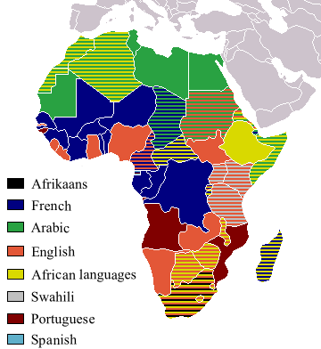
ファイル:Official LanguagesMap-Africa.png
表示
Official_LanguagesMap-Africa.png (360 × 392 ピクセル、ファイルサイズ: 21キロバイト、MIME タイプ: image/png)
ファイルの履歴
過去の版のファイルを表示するには、その版の日時をクリックしてください。
| 日付と時刻 | サムネイル | 寸法 | 利用者 | コメント | |
|---|---|---|---|---|---|
| 現在の版 | 2018年3月16日 (金) 18:05 |  | 360 × 392 (21キロバイト) | Maphobbyist | Updates |
| 2008年5月6日 (火) 12:54 |  | 746 × 813 (250キロバイト) | Ant75 | Updated Madagascar to English, French and Traditional African following 2007 Constitution. | |
| 2008年5月1日 (木) 12:54 |  | 720 × 784 (186キロバイト) | Ant75 | Updated Sudan to English and Arabic following 2005 Constitution. | |
| 2007年3月16日 (金) 19:59 |  | 360 × 392 (14キロバイト) | Rasulo~commonswiki | Updated earlier version due to officialization of Swahili in Uganda. Also corrected the language status of Zimbabwe where Shona and Ndebele are currently co-official with English. | |
| 2005年5月19日 (木) 17:05 |  | 360 × 392 (14キロバイト) | Rydia~commonswiki | Taken from Image:BlankMap-Africa.png. Information from http://www.nationsonline.org/oneworld/index.html and CIA World Factbook {{PD}} |
ファイルの使用状況
このファイルを使用しているページはありません。
グローバルなファイル使用状況
以下に挙げる他のウィキがこの画像を使っています:
- ca.wikipedia.org での使用状況
- de.wikipedia.org での使用状況
- kg.wikipedia.org での使用状況
- oc.wikipedia.org での使用状況
- pam.wikipedia.org での使用状況


