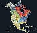
ファイル:North america terrain 2003.jpg
表示

このプレビューのサイズ: 778 × 600 ピクセル。 その他の解像度: 311 × 240 ピクセル | 623 × 480 ピクセル | 996 × 768 ピクセル | 1,280 × 987 ピクセル | 2,560 × 1,974 ピクセル | 3,790 × 2,922 ピクセル。
元のファイル (3,790 × 2,922 ピクセル、ファイルサイズ: 1.9メガバイト、MIME タイプ: image/jpeg)
ファイルの履歴
過去の版のファイルを表示するには、その版の日時をクリックしてください。
| 日付と時刻 | サムネイル | 寸法 | 利用者 | コメント | |
|---|---|---|---|---|---|
| 現在の版 | 2005年9月16日 (金) 16:04 |  | 3,790 × 2,922 (1.9メガバイト) | Saperaud~commonswiki | The North America Tapestry of Time and Terrain (1:8,000,000 scale) is a product of the United States Geological Survey in the I-map series (I-2781). This map was prepared in collaboration with the Geological Survey of Canada and the [[Mexican |
ファイルの使用状況
以下のページがこのファイルを使用しています:
グローバルなファイル使用状況
以下に挙げる他のウィキがこの画像を使っています:
- de.wikipedia.org での使用状況
- en-two.iwiki.icu での使用状況
- en.wikiversity.org での使用状況
- fa.wikipedia.org での使用状況
- www.wikidata.org での使用状況


