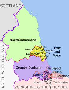
ファイル:North East England counties 2009 map.svg
表示

この SVG ファイルのこの PNG プレビューのサイズ: 482 × 599 ピクセル. その他の解像度: 193 × 240 ピクセル | 386 × 480 ピクセル | 618 × 768 ピクセル | 824 × 1,024 ピクセル | 1,647 × 2,048 ピクセル | 1,082 × 1,345 ピクセル。
元のファイル (SVG ファイル、1,082 × 1,345 ピクセル、ファイルサイズ: 723キロバイト)
ファイルの履歴
過去の版のファイルを表示するには、その版の日時をクリックしてください。
| 日付と時刻 | サムネイル | 寸法 | 利用者 | コメント | |
|---|---|---|---|---|---|
| 現在の版 | 2018年8月14日 (火) 20:16 |  | 1,082 × 1,345 (723キロバイト) | Inops | change letters labelling the boroughs of Tyne and Wearfrom white to black. Hardly intelligible when thumbnailed otherwise |
| 2012年5月5日 (土) 20:11 |  | 1,082 × 1,345 (723キロバイト) | Dr Greg | lighten black boundary line | |
| 2012年5月1日 (火) 22:21 |  | 1,082 × 1,345 (723キロバイト) | Dr Greg | == {{int:filedesc}} == {{Information |Description={{en|Map of the North East England region of England, showing its counties and administrative districts. The county colours are the same as those in [[:File:English metropolitan... |
ファイルの使用状況
以下のページがこのファイルを使用しています:
グローバルなファイル使用状況
以下に挙げる他のウィキがこの画像を使っています:
- ar.wikipedia.org での使用状況
- ca.wikipedia.org での使用状況
- de.wikipedia.org での使用状況
- en-two.iwiki.icu での使用状況
- es.wikipedia.org での使用状況
- fa.wikipedia.org での使用状況
- fr.wikipedia.org での使用状況
- hu.wikipedia.org での使用状況
- lv.wikipedia.org での使用状況
- mr.wikipedia.org での使用状況
- pl.wikipedia.org での使用状況
- pnb.wikipedia.org での使用状況
- th.wikipedia.org での使用状況
- ur.wikipedia.org での使用状況
- vi.wikipedia.org での使用状況
- vls.wikipedia.org での使用状況
- zh-yue.wikipedia.org での使用状況


