ファイル:Nansen Fram Map.svg
表示

この SVG ファイルのこの PNG プレビューのサイズ: 800 × 479 ピクセル. その他の解像度: 320 × 192 ピクセル | 640 × 383 ピクセル | 1,024 × 614 ピクセル | 1,280 × 767 ピクセル | 2,560 × 1,534 ピクセル | 1,003 × 601 ピクセル。
元のファイル (SVG ファイル、1,003 × 601 ピクセル、ファイルサイズ: 183キロバイト)
ファイルの履歴
過去の版のファイルを表示するには、その版の日時をクリックしてください。
| 日付と時刻 | サムネイル | 寸法 | 利用者 | コメント | |
|---|---|---|---|---|---|
| 現在の版 | 2022年9月21日 (水) 16:21 |  | 1,003 × 601 (183キロバイト) | Andrei Stroe | File uploaded using svgtranslate tool (https://svgtranslate.toolforge.org/). Added translation for ro. |
| 2018年9月15日 (土) 21:41 |  | 1,003 × 601 (175キロバイト) | Jay D. Easy | Changed yellow line to gold (ffff00 to ffd7000) to allow for easier legibility when combined with <nowiki>{{legend-line}}</nowiki> in captions, since a yellow line on a white background is often hard to make out. | |
| 2009年10月16日 (金) 17:03 |  | 1,003 × 601 (175キロバイト) | Beao | Tweak. | |
| 2009年10月16日 (金) 17:01 |  | 1,003 × 601 (175キロバイト) | Beao | Tweak. | |
| 2009年10月16日 (金) 16:58 |  | 1,003 × 601 (175キロバイト) | Beao | Removed flowRoot | |
| 2009年10月16日 (金) 16:49 |  | 1,003 × 601 (190キロバイト) | Beao | Redrew lines and deleted link to image. | |
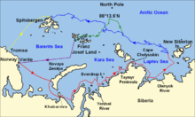
| 2009年10月16日 (金) 14:27 |  | 1,052 × 744 (850キロバイト) | Ruhrfisch | == Summary == {{Information |Description = Map of the Arctic Ocean showing the routes taken during the 1893–96 Nansen's Fram expedition: {{legend|red|Frams's route eastward from Vardø to the Siberian coast, turning nort |
ファイルの使用状況
以下のページがこのファイルを使用しています:
グローバルなファイル使用状況
以下に挙げる他のウィキがこの画像を使っています:
- ca.wikipedia.org での使用状況
- cs.wikipedia.org での使用状況
- en-two.iwiki.icu での使用状況
- it.wikipedia.org での使用状況
- ka.wikipedia.org での使用状況
- ro.wikipedia.org での使用状況
- rue.wikipedia.org での使用状況
- zh-two.iwiki.icu での使用状況


