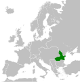
ファイル:Kingdom of Romania (1914).svg
ページのコンテンツが他言語でサポートされていません。
表示

この SVG ファイルのこの PNG プレビューのサイズ: 450 × 456 ピクセル. その他の解像度: 237 × 240 ピクセル | 474 × 480 ピクセル | 758 × 768 ピクセル | 1,011 × 1,024 ピクセル | 2,021 × 2,048 ピクセル。
元のファイル (SVG ファイル、450 × 456 ピクセル、ファイルサイズ: 441キロバイト)
ウィキメディア・コモンズのファイルページにある説明を、以下に表示します。
|
キャプション
このファイルの内容を1行で記述してください
このファイルに描写されている項目
題材
ウィキデータ項目がない値
25 7 2012
451,711 バイト
456 ピクセル
450 ピクセル
image/svg+xml
b3a7a4557b7aaa8cf75a9fa33b0d8ee1bec8892b
ファイルの履歴
過去の版のファイルを表示するには、その版の日時をクリックしてください。
| 日付と時刻 | サムネイル | 寸法 | 利用者 | コメント | |
|---|---|---|---|---|---|
| 現在の版 | 2012年7月25日 (水) 11:34 |  | 450 × 456 (441キロバイト) | TRAJAN 117 | {{Information |Description ={{en|1=The Kingdom of Romania in 1914.}} |Source ={{own}} {{AttribSVG|Blank map of Europe 1914.svg|Alphathon}} |Author =TRAJAN 117 {{created with Inkscape}} |Date =2012-07-25 ... |
ファイルの使用状況
以下のページがこのファイルを使用しています:
グローバルなファイル使用状況
以下に挙げる他のウィキがこの画像を使っています:
- als.wikipedia.org での使用状況
- ar.wikipedia.org での使用状況
- azb.wikipedia.org での使用状況
- az.wikipedia.org での使用状況
- ca.wikipedia.org での使用状況
- cs.wikipedia.org での使用状況
- da.wikipedia.org での使用状況
- de.wikipedia.org での使用状況
- el.wikipedia.org での使用状況
- en-two.iwiki.icu での使用状況
- eo.wikipedia.org での使用状況
- et.wikipedia.org での使用状況
- fi.wikipedia.org での使用状況
- he.wikipedia.org での使用状況
- hu.wikipedia.org での使用状況
- id.wikipedia.org での使用状況
- ka.wikipedia.org での使用状況
- mk.wikipedia.org での使用状況
- ro.wikipedia.org での使用状況
- ru.wikipedia.org での使用状況
- th.wikipedia.org での使用状況
- tr.wikipedia.org での使用状況
- www.wikidata.org での使用状況
- zh-two.iwiki.icu での使用状況
メタデータ
このファイルには、追加情報があります (おそらく、作成やデジタル化する際に使用したデジタルカメラやスキャナーが追加したものです)。
このファイルが元の状態から変更されている場合、修正されたファイルを完全に反映していない項目がある場合があります。
| 短いタイトル | Countries of Europe |
|---|---|
| 画像の説明 | A blank Map of Europe. Every country has an id which is its ISO-3166-1-ALPHA2 code in lower case.
Members of the EU have a class="eu", countries in europe (which I found turkey to be but russia not) have a class="europe".
Certain countries are further subdivided the United Kingdom has gb-gbn for Great Britain and gb-nir for Northern Ireland. Russia is divided into ru-kgd for the Kaliningrad Oblast and ru-main for the Main body of Russia. There is the additional grouping #xb for the "British Islands" (the UK with its Crown Dependencies - Jersey, Guernsey and the Isle of Man)

Contributors.
Original Image: (http://commons.wikimedia.org/wiki/Image:Europe_countries.svg) Júlio Reis (http://commons.wikimedia.org/wiki/User:Tintazul).
Recolouring and tagging with country codes: Marian "maix" Sigler (http://commons.wikimedia.org/wiki/User:Maix)
Improved geographical features: http://commons.wikimedia.org/wiki/User:W!B:
Updated to reflect dissolution of Serbia & Montenegro: http://commons.wikimedia.org/wiki/User:Zirland
Updated to include British Crown Dependencies as seperate entities and regroup them as "British Islands", with some simplifications to the XML and CSS: James Hardy (http://commons.wikimedia.org/wiki/User:MrWeeble)
Released under CreativeCommons Attribution ShareAlike (http://creativecommons.org/licenses/by-sa/2.5/). |


