
ファイル:Isle of Skye UK location map.svg

この SVG ファイルのこの PNG プレビューのサイズ: 562 × 600 ピクセル. その他の解像度: 225 × 240 ピクセル | 450 × 480 ピクセル | 719 × 768 ピクセル | 959 × 1,024 ピクセル | 1,919 × 2,048 ピクセル | 1,334 × 1,424 ピクセル。
元のファイル (SVG ファイル、1,334 × 1,424 ピクセル、ファイルサイズ: 1.56メガバイト)
ウィキメディア・コモンズのファイルページにある説明を、以下に表示します。
|
| 解説 |
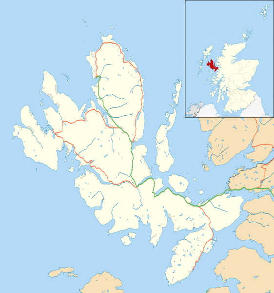
Blank map of the Isle of Skye, UK, as well as the adjacent islands, with the following information shown:
Equirectangular map projection on WGS 84 datum, with N/S stretched 180% Geographic limits:
|
| 日付 | |
| 原典 |
|
| 作者 | Nilfanion, created using Ordnance Survey data |
| 許可 (ファイルの再利用) |
このファイルはクリエイティブ・コモンズ 表示-継承 3.0 非移植ライセンスのもとに利用を許諾されています。 帰属: Contains Ordnance Survey data © Crown copyright and database right
|
| その他のバージョン | File:Isle of Skye UK blank map.svg - Blank map |
ファイルの履歴
過去の版のファイルを表示するには、その版の日時をクリックしてください。
| 日付と時刻 | サムネイル | 寸法 | 利用者 | コメント | |
|---|---|---|---|---|---|
| 現在の版 | 2011年2月4日 (金) 11:20 | | 1,334 × 1,424 (1.56メガバイト) | Nilfanion | {{Information |Description=Blank map of the Isle of Skye, UK, as well as the adjacent islands, with the following information shown: *Coastline, lakes and rivers *Roads and railways *Urban areas Equirectangular map projection on WGS 84 |
ファイルの使用状況
以下の 4 ページがこのファイルを使用しています:
グローバルなファイル使用状況
以下に挙げる他のウィキがこの画像を使っています:
- ar.wikipedia.org での使用状況
- ceb.wikipedia.org での使用状況
- de.wikipedia.org での使用状況
- en-two.iwiki.icu での使用状況
- Portree
- Armadale, Skye
- Dunvegan Castle
- Dunvegan
- Edinbane
- Ullinish
- Kyleakin
- Uig, Snizort
- Duntulm
- Struan, Skye
- Aird of Sleat
- Kylerhea
- Sligachan
- Broadford, Skye
- Isleornsay
- Tarskavaig
- Colbost
- Torrin
- Ose, Skye
- Upper Breakish
- Achachork
- Camasunary
- Boreraig
- Ardvasar
- Bornesketaig
- Borreraig
- Borrodale
- Ashaig
- Bracadale
- Kilmuir, Skye
- Mackinnon Memorial Hospital
- Uigshader
- Borve, Skye
- Trumpan
- Gillen, Skye
- Dun Ringill
- Kilmarie
- Heaste
- Lower Breakish
- Portnalong
- Camastianavaig
- Elgol
- Brogaig
- Bernisdale
- Idrigill
- Luib, Skye
- Lealt, Skye
このファイルのグローバル使用状況を表示する。