
ファイル:Ebola Outbreak Map (ongoing).png

元のファイル (2,454 × 1,502 ピクセル、ファイルサイズ: 841キロバイト、MIME タイプ: image/png)
ウィキメディア・コモンズのファイルページにある説明を、以下に表示します。
|
.png?uselang=ja)
.png?uselang=ja)
.png?uselang=ja&action=history)
.png)

|
このファイルは、最新の情報を受けて更新される可能性があります。 新しい更新が反映されることなく、特定の版のファイルを使用したい場合は、必要な版を別のファイルとしてアップロードしてください。 |
概要
| 解説 |
English: Continuation of the moribund map located at https://commons.wikimedia.org/wiki/File:Map_of_Ebola_Outbreak_-_1_October_2014.svg |
| 日付 | |
| 原典 | 投稿者自身による著作物 |
| 作者 | Раціональне анархіст |
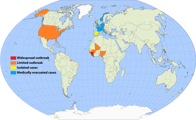
I've undertaken to update an older map, and to simplify the previous cluttered color scheme by removing recorded deaths versus none (a fiddly distinction which required excessive updating). Since a November 20 Wikimedia security rule change, it is apparently no longer possible to upload the .svg scalable format. This file is a 150% .png enlargement of the .svg working document carried over from the previous source.
Suggested rules for updating:
- BLUE: Medically evacuated cases: Any area in which an Ebola case from elsewhere has been treated. Blue regions do not become another color unless there's an actual local outbreak (either due to it escaping the evac facility, or arriving from another source). An ex-blue color cannot become blue again unless it achieves green first (42-day limit passage), then another evac case arrives.
- YELLOW: Isolated cases: Anywhere Ebola is "loose", but for which all or nearly all known and suspected cases are in treatment or quarantine.
- ORANGE: Limited outbreak: An arbitrarily moderate number of persons are infected, including unknown infected "spreaders", but the medical infrastructure is not overwhelmed.
- RED: Widespread outbreak: An out-of-control situation overwhelming available medical infrastructure. Many unidentified infected "spreaders".
Progression: YELLOW > ORANGE > RED > ORANGE > YELLOW.
Please refrain from updating this file if you are not in possession of a master .svg file, and posting a master-derived image in the same format and dimensions as the preceding imagery.
ライセンス

|
この文書は、フリーソフトウェア財団発行のGNUフリー文書利用許諾書 (GNU Free Documentation License) 1.2またはそれ以降のバージョンの規約に基づき、複製や再配布、改変が許可されます。不可変更部分、表紙、背表紙はありません。このライセンスの複製は、GNUフリー文書利用許諾書という章に含まれています。 |
- あなたは以下の条件に従う場合に限り、自由に
- 共有 – 本作品を複製、頒布、展示、実演できます。
- 再構成 – 二次的著作物を作成できます。
- あなたの従うべき条件は以下の通りです。
- 表示 – あなたは適切なクレジットを表示し、ライセンスへのリンクを提供し、変更があったらその旨を示さなければなりません。これらは合理的であればどのような方法で行っても構いませんが、許諾者があなたやあなたの利用行為を支持していると示唆するような方法は除きます。
- 継承 – もしあなたがこの作品をリミックスしたり、改変したり、加工した場合には、あなたはあなたの貢献部分を元の作品とこれと同一または互換性があるライセンスの下に頒布しなければなりません。
ファイルの履歴
過去の版のファイルを表示するには、その版の日時をクリックしてください。
.png&dir=prev)
.png&offset=20150807001640)
.png&offset=&limit=20)
.png&offset=&limit=50)
.png&offset=&limit=100)
.png&offset=&limit=250)
.png&offset=&limit=500)
| 日付と時刻 | サムネイル | 寸法 | 利用者 | コメント | |
|---|---|---|---|---|---|
| 現在の版 | 2017年9月16日 (土) 23:33 | | 2,454 × 1,502 (841キロバイト) | Jamie Tubers | According to the discussion had on the article talkpage: https://en-two.iwiki.icu/wiki/Talk:West_African_Ebola_virus_epidemic/Archive_8#July_2016_map_in_Epidemiology:_Outbreak_section |
| 2017年4月9日 (日) 03:00 |  | 2,454 × 1,502 (854キロバイト) | Agricolae | recolor to reflect historical perspective rather than current situation (after outbreak is over everywhere) | |
| 2016年9月14日 (水) 13:16 |  | 2,454 × 1,502 (861キロバイト) | Heitordp | Surveillance period ended in all countries | |
| 2016年4月3日 (日) 11:12 |  | 2,454 × 1,502 (880キロバイト) | The Anome | Isolated outbreaks in both Guinea and Liberia | |
| 2016年3月31日 (木) 23:14 |  | 2,454 × 1,502 (861キロバイト) | Heitordp | Sierra Leone free, new cases in Guinea | |
| 2016年2月7日 (日) 22:05 |  | 2,454 × 1,502 (826キロバイト) | Heitordp | Liberia free again, isolated cases in Sierra Leone | |
| 2015年12月29日 (火) 13:58 |  | 2,454 × 1,502 (885キロバイト) | The Anome | Guinea now Ebola-free as of 29 December 2015, Liberia only with yellow status now | |
| 2015年11月22日 (日) 01:10 |  | 2,454 × 1,502 (826キロバイト) | Heitordp | Sierra Leone free, new case in Liberia | |
| 2015年9月5日 (土) 07:04 |  | 2,454 × 1,502 (824キロバイト) | Раціональне анархіст | Liberia clear again. | |
| 2015年8月7日 (金) 00:16 |  | 2,454 × 1,502 (824キロバイト) | Раціональне анархіст | Sierra Leone and Guinea improved to yellow after neither country has had more than five new cases per week for two reporting cycles. |
ファイルの使用状況
以下のページがこのファイルを使用しています:
グローバルなファイル使用状況
以下に挙げる他のウィキがこの画像を使っています:
- ca.wikipedia.org での使用状況
- en-two.iwiki.icu での使用状況
- en.wikiversity.org での使用状況
- fi.wikipedia.org での使用状況
- fr.wikinews.org での使用状況
- hu.wikipedia.org での使用状況
- ko.wikipedia.org での使用状況
- no.wikipedia.org での使用状況
- pl.wikipedia.org での使用状況
- ro.wikipedia.org での使用状況
- ru.wikipedia.org での使用状況
- rw.wikipedia.org での使用状況
- uk.wikipedia.org での使用状況
- www.wikidata.org での使用状況
.png)