
ファイル:Daventry UK locator map.svg

この SVG ファイルのこの PNG プレビューのサイズ: 524 × 600 ピクセル. その他の解像度: 210 × 240 ピクセル | 419 × 480 ピクセル | 671 × 768 ピクセル | 895 × 1,024 ピクセル | 1,789 × 2,048 ピクセル | 1,106 × 1,266 ピクセル。
元のファイル (SVG ファイル、1,106 × 1,266 ピクセル、ファイルサイズ: 995キロバイト)
ウィキメディア・コモンズのファイルページにある説明を、以下に表示します。
|
| 解説 |
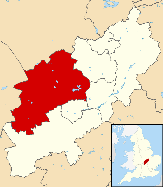
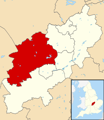
Map of Northamptonshire, UK with Daventry highlighted. Equirectangular map projection on WGS 84 datum, with N/S stretched 160% |
| 日付 | |
| 原典 |
|
| 作者 | Nilfanion, created using Ordnance Survey data |
| 許可 (ファイルの再利用) |
このファイルはクリエイティブ・コモンズ 表示-継承 3.0 非移植ライセンスのもとに利用を許諾されています。 帰属: Contains Ordnance Survey data © Crown copyright and database right
|
ファイルの履歴
過去の版のファイルを表示するには、その版の日時をクリックしてください。
| 日付と時刻 | サムネイル | 寸法 | 利用者 | コメント | |
|---|---|---|---|---|---|
| 現在の版 | 2011年8月13日 (土) 22:13 | | 1,106 × 1,266 (995キロバイト) | Nilfanion | {{Information |Description=Map of Northamptonshire, UK with Daventry highlighted. Equirectangular map projection on WGS 84 datum, with N/S stretched 160% |Source=Ordnance Survey [http |
ファイルの使用状況
以下の 2 ページがこのファイルを使用しています:
グローバルなファイル使用状況
以下に挙げる他のウィキがこの画像を使っています:
- bg.wikipedia.org での使用状況
- cy.wikipedia.org での使用状況
- en-two.iwiki.icu での使用状況
- Long Buckby
- Braunston
- Naseby
- Daventry
- Althorp
- Daventry District
- East Farndon
- Welford, Northamptonshire
- Crick, Northamptonshire
- Arthingworth
- Ashby St Ledgers
- Badby
- Barby, Northamptonshire
- Boughton, Northamptonshire
- Woodford Halse
- Brixworth
- Brockhall, Northamptonshire
- Byfield, Northamptonshire
- Canons Ashby
- Watford, Northamptonshire
- Yelvertoft
- Winwick, Northamptonshire
- Whilton
- West Haddon
- Walgrave
- Upper Catesby
- Thornby, Northamptonshire
- Teeton
- Sulby, Northamptonshire
- Church Stowe
- Staverton, Northamptonshire
- Spratton
- Sibbertoft
- Scaldwell
- Ravensthorpe, Northamptonshire
- Preston Capes
- Pitsford
- Overstone, Northamptonshire
- Old, Northamptonshire
- Norton, Northamptonshire
- Newnham, Northamptonshire
- Moulton, Northamptonshire
- Marston Trussell
- Maidwell
- Kilsby
- Lamport, Northamptonshire
- Lilbourne
- Little Brington
このファイルのグローバル使用状況を表示する。