
ファイル:Chagatai Khanate (1490).png

このプレビューのサイズ: 800 × 451 ピクセル。 その他の解像度: 320 × 180 ピクセル | 640 × 360 ピクセル | 1,202 × 677 ピクセル。
元のファイル (1,202 × 677 ピクセル、ファイルサイズ: 792キロバイト、MIME タイプ: image/png)
ウィキメディア・コモンズのファイルページにある説明を、以下に表示します。
|
.png?uselang=ja)
.png?uselang=ja)
.png?uselang=ja&action=history)
.png)
概要
| 解説 |
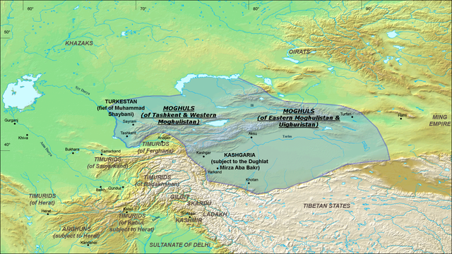
English: A map of the Moghul Chagatai Khanate in 1490 CE. Note: This map is compressed in vertical direction. Please, expand it about 1.3 times to see it undistorted.
ReferencesInformation for the borders of the Moghul khanate came mostly from these two sources:
|
| 日付 | 2008年7月22日 (当初のアップロード日) |
| 原典 | en.wikipedia からコモンズに Betta27 によって移動されました。 |
| 作者 | 英語版ウィキペディアのRo4444さん |
ライセンス
この作品の著作権者であるRo4444 at the English Wikipediaは、この作品を以下のライセンスで提供しています。

|
この文書は、フリーソフトウェア財団発行のGNUフリー文書利用許諾書 (GNU Free Documentation License) 1.2またはそれ以降のバージョンの規約に基づき、複製や再配布、改変が許可されます。不可変更部分、表紙、背表紙はありません。このライセンスの複製は、GNUフリー文書利用許諾書という章に含まれています。 |
| このファイルはクリエイティブ・コモンズ 表示-継承 3.0 非移植ライセンスのもとに利用を許諾されています。 | ||
| 帰属: Ro4444 at the English Wikipedia | ||
| ||
| このライセンスのテンプレートは、GFDLのライセンス・アップデートによりこのファイルに追加されたものです。 |
元のアップロードログ
元のファイルページはこちら。以下の利用者は全てen.wikipediaに属します。
- 2008-07-22 06:20 Ro4444 1202×677× (811049 bytes) {{Information |Description={{en|1=A map of the Moghul (Chagatai) Khanate in 1490}} |Source=Own work by uploader |Author=ro4444 |Date=22 July 2008 |Permission= |other_versions= }} {{ImageUpload|full}} ==References== Information for the borders of the Mog
]]
ファイルの履歴
過去の版のファイルを表示するには、その版の日時をクリックしてください。
| 日付と時刻 | サムネイル | 寸法 | 利用者 | コメント | |
|---|---|---|---|---|---|
| 現在の版 | 2010年10月30日 (土) 07:16 | | 1,202 × 677 (792キロバイト) | Betta27 | {{Information |Description={{en|''no original description''}} |Source=Transferred from [http://en-two.iwiki.icu en.wikipedia]; transfer was stated to be made by User:Betta27. |Date={{Date|2008|07|22}} (original upload date) |Author=. Original uploader |
ファイルの使用状況
以下のページがこのファイルを使用しています:
グローバルなファイル使用状況
以下に挙げる他のウィキがこの画像を使っています:
- azb.wikipedia.org での使用状況
- de.wikipedia.org での使用状況
- en-two.iwiki.icu での使用状況
- es.wikipedia.org での使用状況
- fa.wikipedia.org での使用状況
- fr.wikipedia.org での使用状況
- it.wikipedia.org での使用状況
- ko.wikipedia.org での使用状況
- lt.wikipedia.org での使用状況
- mni.wikipedia.org での使用状況
- mn.wikipedia.org での使用状況
- no.wikipedia.org での使用状況
- ru.wikipedia.org での使用状況
- sd.wikipedia.org での使用状況
- simple.wikipedia.org での使用状況
- sl.wikipedia.org での使用状況
- ta.wikipedia.org での使用状況
- tr.wikipedia.org での使用状況
- uz.wikipedia.org での使用状況
- vi.wikipedia.org での使用状況
- zh-two.iwiki.icu での使用状況
.png)