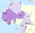
ファイル:Carte de l'Afrique-Occidentale française, 1935.svg
表示

この SVG ファイルのこの PNG プレビューのサイズ: 634 × 600 ピクセル. その他の解像度: 254 × 240 ピクセル | 507 × 480 ピクセル | 812 × 768 ピクセル | 1,082 × 1,024 ピクセル | 2,164 × 2,048 ピクセル | 839 × 794 ピクセル。
元のファイル (SVG ファイル、839 × 794 ピクセル、ファイルサイズ: 1.87メガバイト)
ファイルの履歴
過去の版のファイルを表示するには、その版の日時をクリックしてください。
| 日付と時刻 | サムネイル | 寸法 | 利用者 | コメント | |
|---|---|---|---|---|---|
| 現在の版 | 2023年12月12日 (火) 13:09 |  | 839 × 794 (1.87メガバイト) | Hogweard | Frontiers internaux |
| 2023年12月12日 (火) 07:51 |  | 839 × 794 (1.87メガバイト) | Hogweard | Finalement, je crois... | |
| 2023年12月12日 (火) 07:49 |  | 839 × 794 (1.87メガバイト) | Hogweard | Tchad | |
| 2023年12月12日 (火) 07:46 |  | 839 × 794 (1.87メガバイト) | Hogweard | et encore | |
| 2023年12月12日 (火) 07:43 |  | 839 × 794 (1.87メガバイト) | Hogweard | Divers noms | |
| 2023年12月11日 (月) 23:28 |  | 839 × 794 (1.87メガバイト) | Hogweard | {{Information |Description=Carte de l'Afrique-Occidentale française en l'an 1935 |Source={{f|Africa map 1935.svg}} |Date=2023-12-11 |Author={{u|Hogweard}} |Permission= |other_versions= }} Category:SVG maps showing history of Africa Category:Maps of 20th-century Africa Category:French-language SVG maps of Africa Category:Maps of French West Africa |
ファイルの使用状況
以下のページがこのファイルを使用しています:
グローバルなファイル使用状況
以下に挙げる他のウィキがこの画像を使っています:
- bn.wikipedia.org での使用状況
- de.wikipedia.org での使用状況
- en-two.iwiki.icu での使用状況
- fr.wikipedia.org での使用状況
- ko.wikipedia.org での使用状況
- pl.wikipedia.org での使用状況
