
ファイル:Bridgeport, California, on the eastern slope of Sierra Mountains, and the county seat of Mono County LCCN2013633802.jpg

このプレビューのサイズ: 800 × 404 ピクセル。 その他の解像度: 320 × 161 ピクセル | 640 × 323 ピクセル | 1,024 × 517 ピクセル | 1,280 × 646 ピクセル | 2,560 × 1,292 ピクセル | 7,360 × 3,714 ピクセル。
元のファイル (7,360 × 3,714 ピクセル、ファイルサイズ: 7.37メガバイト、MIME タイプ: image/jpeg)
ウィキメディア・コモンズのファイルページにある説明を、以下に表示します。
|
概要
| 解説 |
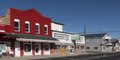
English: Title: Bridgeport, California, on the eastern slope of Sierra Mountains, and the county seat of Mono County
Physical description: 1 photograph : digital, tiff file, color. Notes: Title, date, and keywords provided by the photographer.; Credit line: The Jon B. Lovelace Collection of California Photographs in Carol M. Highsmith's America Project, Library of Congress, Prints and Photographs Division.; Gift; The Capital Group Companies Charitable Foundation in memory of Jon B. Lovelace; 2012; (DLC/PP-2012:063).; Forms part of: Jon B. Lovelace Collection of California Photographs in Carol M. Highsmith's America Project in the Carol M. Highsmith Archive.; Located near the ghost town Bodie on the eastern slope of the Sierra Mountains, it is the county seat of Mono County. Formerly known as Big Meado, the town attracts tourists, many of whom come to the area for well-known trout streams and lakes. |
||||||||||||||||||||||||||
| 日付 | 撮影日:2012年11月23日, 14:21(Exifデータによる) | ||||||||||||||||||||||||||
| 原典 |
Library of Congress
|
||||||||||||||||||||||||||
| 作者 |
|
||||||||||||||||||||||||||
| 許可 (ファイルの再利用) |
No known restrictions on publication.
|
||||||||||||||||||||||||||
| その他のバージョン |
|
||||||||||||||||||||||||||


| カメラの位置 | | 以下のサービスでこの位置を確認する: オープンストリートマップ |
|---|
ライセンス
| この著作物はアメリカ議会図書館Carol M. Highsmith Archiveのコレクション収蔵品です。同図書館によれば、この著作物の使用に関しては著作権に依拠する如何なる制限事項も認められません。 Carol M. Highsmith has stipulated that her photographs are in the public domain. Photographs of sculpture or other works of art may be restricted by the copyright of the artist; see Commons:FOP US#Artworks and sculptures for more information. |
 |
ファイルの履歴
過去の版のファイルを表示するには、その版の日時をクリックしてください。
| 日付と時刻 | サムネイル | 寸法 | 利用者 | コメント | |
|---|---|---|---|---|---|
| 現在の版 | 2024年8月3日 (土) 23:36 | | 7,360 × 3,714 (7.37メガバイト) | ReneeWrites | =={{int:filedesc}}== {{Information |description={{en|1=''Title:'' Bridgeport, California, on the eastern slope of Sierra Mountains, and the county seat of Mono County ''Physical description:'' 1 photograph : digital, tiff file, color. ''Notes:'' Title, date, and keywords provided by the photographer.; Credit line: The Jon B. Lovelace Collection of California Photographs in Carol M. Highsmith's America Project, Library of Congress, Prints and Photographs Division.; Gift; The Capital Group Comp... |
ファイルの使用状況
以下のページがこのファイルを使用しています:
グローバルなファイル使用状況
以下に挙げる他のウィキがこの画像を使っています:
- bg.wikipedia.org での使用状況
- ce.wikipedia.org での使用状況
- en-two.iwiki.icu での使用状況
- en.wikivoyage.org での使用状況
- eo.wikipedia.org での使用状況
- fr.wikipedia.org での使用状況
- he.wikivoyage.org での使用状況
- hu.wikipedia.org での使用状況
- it.wikipedia.org での使用状況
- it.wikivoyage.org での使用状況
- lld.wikipedia.org での使用状況
- pl.wikipedia.org での使用状況
- ru.wikipedia.org での使用状況
- simple.wikipedia.org での使用状況
- sr.wikipedia.org での使用状況
- tt.wikipedia.org での使用状況
- uk.wikipedia.org での使用状況
- www.wikidata.org での使用状況