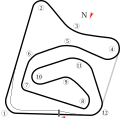
ファイル:Autódromo Internacional Nelson Piquet in Brasília.svg
表示

この SVG ファイルのこの PNG プレビューのサイズ: 610 × 600 ピクセル. その他の解像度: 244 × 240 ピクセル | 488 × 480 ピクセル | 781 × 768 ピクセル | 1,041 × 1,024 ピクセル | 2,083 × 2,048 ピクセル | 895 × 880 ピクセル。
元のファイル (SVG ファイル、895 × 880 ピクセル、ファイルサイズ: 19キロバイト)
ファイルの履歴
過去の版のファイルを表示するには、その版の日時をクリックしてください。
| 日付と時刻 | サムネイル | 寸法 | 利用者 | コメント | |
|---|---|---|---|---|---|
| 現在の版 | 2024年8月10日 (土) 23:28 |  | 895 × 880 (19キロバイト) | MMichkov | Changed the direction & corner numbering |
| 2008年7月17日 (木) 23:05 |  | 895 × 880 (26キロバイト) | Will Pittenger | New version has north indicator that I forgot to add | |
| 2008年7月17日 (木) 11:38 |  | 895 × 880 (25キロバイト) | Will Pittenger | {{Information |Description={{en|1=Track map for w:Autódromo Internacional Nelson Piquet (Brasília). Don't confuse this track with the one that commonly goes by the same name in Rio.}} |Source=Own work by uploader |Author=[[User:Will Pittenger|Will |
ファイルの使用状況
以下のページがこのファイルを使用しています:
グローバルなファイル使用状況
以下に挙げる他のウィキがこの画像を使っています:
- de.wikipedia.org での使用状況
- en-two.iwiki.icu での使用状況
- es.wikipedia.org での使用状況
- fr.wikipedia.org での使用状況
- id.wikipedia.org での使用状況
- it.wikipedia.org での使用状況
- nl.wikipedia.org での使用状況
- pl.wikipedia.org での使用状況
- pt.wikipedia.org での使用状況
- www.wikidata.org での使用状況
