コンテンツにスキップ

英文维基 | 中文维基 | 日文维基 | 草榴社区

ファイル:AMH-4492-NA Map of the fort at Jaffanapatnam.jpg

ページのコンテンツが他言語でサポートされていません。

元のファイル (2,400 × 1,730 ピクセル、ファイルサイズ: 505キロバイト、MIME タイプ: image/jpeg)

概要

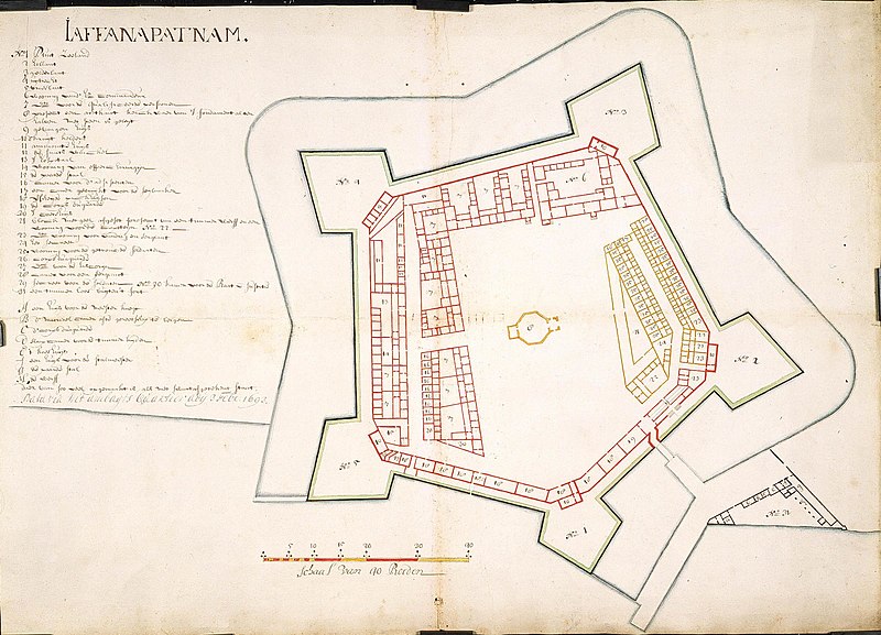
Nederlands: Plattegrond van het fort te Jaffanapatnam
                     English:  Map of the fort at Jaffanapatnam
  (Wikidata search (Cirrus search) Wikidata query (SPARQL)  Create new Wikidata item based on this file)
作者
Nederlands: Anoniem / Anonymous
English: Anoniem / Anonymous
タイトル
Nederlands: Plattegrond van het fort te Jaffanapatnam
English: Map of the fort at Jaffanapatnam
解説
Nederlands: Titel catalogus Leupe (NA): Platte grond van het Kasteel te Jaffanapatnam.

Plattegrond van de vesting te Jaffanapatnam, met bouw van een woning voor de timmerman; In zwart zijn de werken aangegeven die gebouwd zijn in 1693; in geel de geplande bouw van timmermanswoning.

Notities verso: Kaart van het Casteel tot J [...] nr. 2. [Gedrukt etiket] nr. 545..
English: According to the Leupe catalogue (NA), the original title reads: Platte grond van het Kasteel te Jaffanapatnam.

Map of the fort at Jaffanapatnam, with buildings and a house for the carpenter. The buildings constructed in 1693 are indicated in black, while the planned house for the carpenter is shown in yellow.

Notes on reverse: Kaart van het Casteel tot J [...] nr. 2. [Printed label] nr. 545..
日付 1693年2月3日
date QS:P571,+1693-02-03T00:00:00Z/11
技法
Nederlands: ingekleurde tekening op papier
English: coloured drawing on paper
寸法 高さ: 71 cm;幅: 51 cm
dimensions QS:P2048,71U174728
dimensions QS:P2049,51U174728
institution QS:P195,Q1857081
台帳番号
NL-HaNA_4.VEL_998 (old number: VEL0998)
銘文等の文字
Jaffanapatnam
備考
English: Subjects: factory / workshop, fortification, key, chart / map / plan
Nederlands: Onderwerpen: fabriek / werkplaats, vesting, legenda, plattegrond / kaart
English: Post: this image is related to a VOC trading post called Jaffna
情報源/撮影者 Source at the Atlas of Mutual Heritage - Source at the Nationaal Archief
許可
(ファイルの再利用)
このファイルは、パブリックドメインの状態にある平面的な美術の著作物を写真術によって忠実に複製したものです。このような複製はアメリカ合衆国においてパブリックドメインの状態にあります。その他の地域では再利用に制限がかかる場合があります。詳しくはReuse of PD-Art photographsをご覧ください。美術の著作物としての原図は、次の理由によりパブリックドメインの状態にあります。
Public domain

この著作物は、著作権の保護期間が著作者の死後100年以下である国・地域においてパブリックドメインの状態にあります。


この著作物がアメリカ合衆国においてパブリックドメインの状態にあることを示すために、アメリカ合衆国のPDタグも貼る必要があります。
このファイルは著作権法の既知の制約(隣接権や関連する権利を含む)から自由であると特定されています。
被写体の位置9° 40′ 05.8″ 北, 80° 00′ 15.23″ 東 Kartographer map based on OpenStreetMap.以下のサービスでこの位置を確認する: オープンストリートマップinfo

キャプション

このファイルの内容を1行で記述してください

このファイルに描写されている項目

題材

9°40'5.797"N, 80°0'15.228"E

745195b353dfbb03839af1dfced43f920dd74dfe

517,263 バイト

1,730 ピクセル

2,400 ピクセル

ファイルの履歴

過去の版のファイルを表示するには、その版の日時をクリックしてください。

日付と時刻サムネイル寸法利用者コメント
現在の版2014年6月10日 (火) 16:242014年6月10日 (火) 16:24時点における版のサムネイル2,400 × 1,730 (505キロバイト)HuskyBot== {{int:filedesc}} == {{Artwork |title = {{nl|1=Plattegrond van het fort te Jaffanapatnam}} {{en|1=Map of the fort at Jaffanapatnam}} |description = {{nl|1=Titel catalogus Leupe (NA): ''Platte grond van het Ka...

以下の​ 2 ページがこのファイルを使用しています:

グローバルなファイル使用状況

以下に挙げる他のウィキがこの画像を使っています: