
ファイル:1879 Coney Island.jpg

このプレビューのサイズ: 800 × 168 ピクセル。 その他の解像度: 320 × 67 ピクセル | 640 × 134 ピクセル | 1,024 × 215 ピクセル | 4,434 × 930 ピクセル。
元のファイル (4,434 × 930 ピクセル、ファイルサイズ: 1.03メガバイト、MIME タイプ: image/jpeg)
ウィキメディア・コモンズのファイルページにある説明を、以下に表示します。
|
概要
| 記述 |
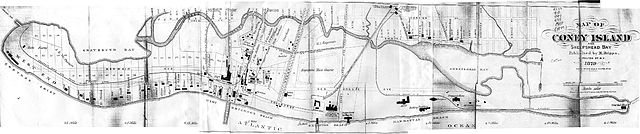
An 1879 map of Coney Island, Brooklyn, New York. New York, USA. This map plots existing property lines and structures from that time period and shows the then still existent "Coney Island Creek'. It also contains an overlay (doted lines) showing a proposed change/expansion of the street "grid" that would follow a planed filling and dredging of Coney Island Creek to make a Gravesend Ship Canal running in an almost straight line east to west. Map stitched together from [1]. |
| 日付 | /2016/ /1873. :1879 |
| 原典 | http://www.nycgovparks.org/parks/ |
| Georeferencing | If inappropriate please set warp_status = skip to hide. |
ライセンス
|
この著作物は、著作権の保護期間が著作者の死後70年以下である国・地域においてパブリックドメインの状態にあります。 | |
| このファイルは著作権法の既知の制約(隣接権や関連する権利を含む)から自由であると特定されています。 | |
ファイルの履歴
過去の版のファイルを表示するには、その版の日時をクリックしてください。
| 日付と時刻 | サムネイル | 寸法 | 利用者 | コメント | |
|---|---|---|---|---|---|
| 現在の版 | 2005年3月11日 (金) 14:41 | 4,434 × 930 (1.03メガバイト) | SPUI~commonswiki | {{PD}}An 1879 map of Coney Island, Brooklyn, New York. New York, USA. Stitched together from [http://www.bklyn-genealogy-info.com/Map/1873.Coney.html].category:Coney Island, New Yorkcategory:New York City Subway |
ファイルの使用状況
以下のページがこのファイルを使用しています:
グローバルなファイル使用状況
以下に挙げる他のウィキがこの画像を使っています:
- de.wikipedia.org での使用状況
- en-two.iwiki.icu での使用状況
- es.wikipedia.org での使用状況