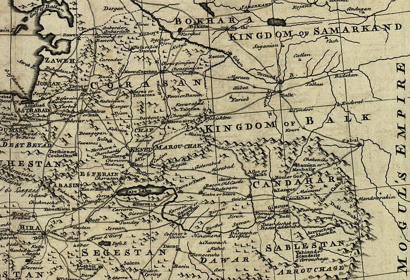
ファイル:Map of Afghanistan during the Safavid and Moghul Empire.jpg
表示

このプレビューのサイズ: 800 × 548 ピクセル。 その他の解像度: 320 × 219 ピクセル | 640 × 439 ピクセル | 1,024 × 702 ピクセル | 1,280 × 878 ピクセル | 2,532 × 1,736 ピクセル。
元のファイル (2,532 × 1,736 ピクセル、ファイルサイズ: 1.16メガバイト、MIME タイプ: image/jpeg)
ファイルの履歴
過去の版のファイルを表示するには、その版の日時をクリックしてください。
| 日付と時刻 | サムネイル | 寸法 | 利用者 | コメント | |
|---|---|---|---|---|---|
| 現在の版 | 2011年3月2日 (水) 02:50 |  | 2,532 × 1,736 (1.16メガバイト) | Officer | {{Information |Description= |Source= |Date= |Author= |Permission= |other_versions= }} |
| 2011年3月2日 (水) 02:42 |  | 2,342 × 1,682 (1.04メガバイト) | Officer | {{Information |Description= |Source= |Date= |Author= |Permission= |other_versions= }} | |
| 2011年3月2日 (水) 02:32 |  | 2,402 × 1,599 (1.02メガバイト) | Officer | {{Information |Description= |Source= |Date= |Author= |Permission= |other_versions= }} | |
| 2011年3月2日 (水) 01:37 |  | 2,064 × 1,607 (856キロバイト) | Officer | {{Information |Description= |Source= |Date= |Author= |Permission= |other_versions= }} | |
| 2010年3月12日 (金) 14:39 |  | 1,810 × 1,810 (915キロバイト) | Officer | {{Information |Description=Map of Afghanistan during the Safavid and Mughal Empire, from the 16th century to 1747 when the current nation-state was created. |Source=[http://memory.loc.gov/ The Library of Congress, American Memory] - [http://memory.loc.gov | |
| 2010年1月21日 (木) 03:48 |  | 2,056 × 1,574 (983キロバイト) | Officer | {{Information |Description=Map of Afghanistan during the Safavid and Mughal Empire, from the 16th century to 1747 when the current nation-state was created. |Source=[http://memory.loc.gov/ The Library of Congress, American Memory] - [http://memory.loc.gov | |
| 2009年11月19日 (木) 01:29 |  | 1,679 × 1,678 (790キロバイト) | Officer | {{Information |Description=Map of Afghanistan during the Safavid and Mughal Empire, from the 16th century to 1747 when the current nation-state was created. |Source=[http://memory.loc.gov/ The Library of Congress, American Memory] - [http://memory.loc.gov |
ファイルの使用状況
以下のページがこのファイルを使用しています:
グローバルなファイル使用状況
以下に挙げる他のウィキがこの画像を使っています:
- ar.wikipedia.org での使用状況
- azb.wikipedia.org での使用状況
- az.wikipedia.org での使用状況
- bn.wikipedia.org での使用状況
- el.wikipedia.org での使用状況
- en-two.iwiki.icu での使用状況
- fa.wikipedia.org での使用状況
- he.wikipedia.org での使用状況
- hi.wikipedia.org での使用状況
- id.wikipedia.org での使用状況
- it.wikipedia.org での使用状況
- nl.wikipedia.org での使用状況
- no.wikipedia.org での使用状況
- pt.wikipedia.org での使用状況
- ru.wikipedia.org での使用状況
- ta.wikipedia.org での使用状況
- te.wikipedia.org での使用状況
- tg.wikipedia.org での使用状況
- uk.wikipedia.org での使用状況
- ur.wikipedia.org での使用状況
- www.wikidata.org での使用状況
- zh-two.iwiki.icu での使用状況


